IMAGES TAKEN NEAR TO
Comber Grove, LONDON, SE5 0UJ
Introduction
This page details the photographs taken nearby to Comber Grove, SE5 0UJ by members of the Geograph project.
The Geograph project started in 2005 with the aim of publishing, organising and preserving representative images for every square kilometre of Great Britain, Ireland and the Isle of Man.

There are currently over 7.5m images from over14,400 individuals and you can help contribute to the project by visiting https://www.geograph.org.uk
Image Map (Loading...)


Getting Data...Please wait
Leaflet Map data © OpenStreetMap
Images are licensed for reuse under creativecommons.org/licenses/by-sa/2.0
Notes
- Clicking on the map will re-center to the selected point.
- The higher the marker number, the further away the image location is from the centre of the postcode.
Image Listing (194 Images Found)
Images are licensed for reuse under creativecommons.org/licenses/by-sa/2.0
Image
Details
Distance
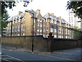
1
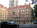
Camberwell: Cameron House, Comber Grove, SE5
This is one wing of a particularly fine U-shaped block of former London County Council flats, built between the wars in a style that has as its origin large town houses of the early eighteenth century Queen Anne period. As a later example of social housing behind can be seen one of the five tower blocks on the Wyndham Estate, this one being Coniston House.
The road is Comber Grove, although from early Ordnance Survey maps, certainly up to 1938, it was Leipzig Road, the name presumably falling out of favour in the light of subsequent events.
Image: © Nigel Cox
Taken: 11 Sep 2009
0.01 miles
5
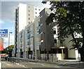
"Mixed-use" block on Wyndham Road
This block is planned to have 56 1, 2, and 3-bedroom flats together with retail/office space on the ground floor. The land was previously occupied by an unsightly pile of car parts known as Wyndham Garage.
Image: © graham ross
Taken: 3 Sep 2007
0.03 miles
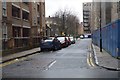
7
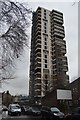
Tower blocks in Camberwell
These four tower blocks are, from left to right, Otterburn House, Crossmount House, Coniston House and Kevan House. There is a fifth in the group, Laird House, which is off the picture to the right. They are grouped around Wyndham Road (in the photo). The photo was taken from outside the entrance to St Michael's Academy which explains the traffic calming and the barriers on the pavement in the foreground.
Image: © Stephen Craven
Taken: 21 Apr 2010
0.04 miles
9
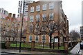
Camberwell: Comber Grove School, SE5
Since the School is shown on the Ordnance Survey map of 1896 but not on the 1882 edition, its date of origin can be placed at around 1890. A curious change of circumstances has come about here. When the school was built at that time it was a latecomer to an already well-established residential community of terraced houses. Now it is the survivor amongst a sea of much more modern buildings such as the adjacent Image The road in front is Comber Grove but the old Ordnance Survey maps show it as Leipzig Road, certainly up to 1938, so presumably the school was not originally called Comber Grove.
Image: © Nigel Cox
Taken: 11 Sep 2009
0.05 miles