IMAGES TAKEN NEAR TO
Grosvenor Terrace, LONDON, SE5 0NL
Introduction
This page details the photographs taken nearby to Grosvenor Terrace, SE5 0NL by members of the Geograph project.
The Geograph project started in 2005 with the aim of publishing, organising and preserving representative images for every square kilometre of Great Britain, Ireland and the Isle of Man.

There are currently over 7.5m images from over14,400 individuals and you can help contribute to the project by visiting https://www.geograph.org.uk
Image Map (Loading...)


Getting Data...Please wait
Leaflet Map data © OpenStreetMap
Images are licensed for reuse under creativecommons.org/licenses/by-sa/2.0
Notes
- Clicking on the map will re-center to the selected point.
- The higher the marker number, the further away the image location is from the centre of the postcode.
Image Listing (86 Images Found)
Images are licensed for reuse under creativecommons.org/licenses/by-sa/2.0
Image
Details
Distance
1
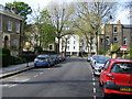
Urlwin Street
Picture taken looking toward Grosvenor Park
Image: © PAUL FARMER
Taken: 18 Apr 2009
0.09 miles
2
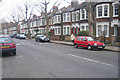
Victorian houses on John Ruskin Street, London
Image: © Oast House Archive
Taken: 9 Jan 2005
0.11 miles
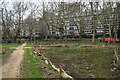
4

Housing estate off Cook' Road, London
Filming 'Xmas' Special of Doctor Who. One of the characters lived in the building to right.
Image: © Oast House Archive
Taken: 27 Jul 2005
0.13 miles
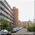
5

Jack Hobbs Youth Centre, Brandon Estate, 1966
Built as an integral part of the estate facilities.
Image: © Alan Murray-Rust
Taken: 25 Apr 1966
0.14 miles
6
East side of Horsman House, Goschen Estate, Camberwell, south London
The view is north from the entry off Bethwin Road. At the time Southwark Council was announcing a £300 million major refurbishment of this and the Crawford Road estate. A railway viaduct out-of-shot right carries the busy Thameslink line and other services. Just visible to the right of the low block is the distinctive three-hole top of the Strata Tower at Elephant and Castle.
Image: © Robin Stott
Taken: 5 Apr 2016
0.15 miles
7

The Canterbury Arms, Kennington
On 2-4 Maddock's Way. Seen from Cook's Road. Napier House is on the left.
Image: © David Anstiss
Taken: 27 Nov 2009
0.16 miles
8

Shops on Maddock Way, SE17
A shopping precinct on the Brandon Estate. The tower block is Napier House. See Image, which looks in the opposite direction.
Image: © Derek Harper
Taken: 17 Oct 2011
0.16 miles
10

Maddock Way, Brandon Estate, 1966
Shopping precinct forming part of the Brandon Estate development of the late 1950s/early 1960s. Compare with https://www.geograph.org.uk/photo/911234 from 2005. One particular feature that has disappeared is the row of 'flags' indicating individual shops in the row.
Image: © Alan Murray-Rust
Taken: 25 Apr 1966
0.16 miles