IMAGES TAKEN NEAR TO
Camberwell Road, LONDON, SE5 0EE
Introduction
This page details the photographs taken nearby to Camberwell Road, SE5 0EE by members of the Geograph project.
The Geograph project started in 2005 with the aim of publishing, organising and preserving representative images for every square kilometre of Great Britain, Ireland and the Isle of Man.

There are currently over 7.5m images from over14,400 individuals and you can help contribute to the project by visiting https://www.geograph.org.uk
Image Map
Images are licensed for reuse under creativecommons.org/licenses/by-sa/2.0
Notes
- Clicking on the map will re-center to the selected point.
- The higher the marker number, the further away the image location is from the centre of the postcode.
Image Listing (174 Images Found)
Images are licensed for reuse under creativecommons.org/licenses/by-sa/2.0
Image
Details
Distance
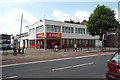
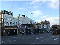
2
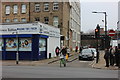
Shops, Sunday lunchtime, Camberwell Road, London
Image: © Robin Stott
Taken: 5 Apr 2015
0.02 miles
4
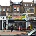
Power Church International, Camberwell Road
A former shop and house is now a church, one of many that have adapted to unlikely premises in this part of London: "A Place of Divine Solution".
Image: © Robin Stott
Taken: 25 Aug 2013
0.04 miles
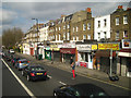
5
Wyndham Road, junction with Walworth Road
Image: © Robert Eva
Taken: 25 Jan 2020
0.05 miles
6
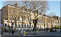
131-157 Camberwell Road
An excellent Georgian terrace, unusual in its surviving length. This street must once have had a loftier status than it currently does. Very uniform with a first-floor sillband running its whole length. Each house is of three bays and three storeys plus basement. Arched ground floor windows set into arched recesses, a common motif in late Georgian terraces and much in evidence in this area. Grade II listed.
Much of this terrace has, for some years, been occupied by Cambridge House, a local voluntary and community charity.
Image: © Stephen Richards
Taken: 1 Apr 2012
0.05 miles
7
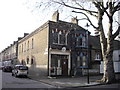
RW Fowlds Upholsterers Shop Addington Square Camberwell
The company was established in 1870 and is at the junction of Addington Square and Kitson Road
Image: © PAUL FARMER
Taken: 31 Jan 2010
0.05 miles
8
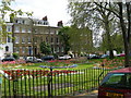
Addington Square SE5
This square is just off Walworth Road. It gained some notoriety during the 1960s because the Richardson Brothers had an illegal "drinking club" named the "Addington Club" in the square. They also had a scrapyard near here from where they ran their criminal enterprises. (See the site in this photo http://www.geograph.org.uk/photo/200880 ) The area has changed a lot since then, physically and socially.
Image: © Danny P Robinson
Taken: 7 May 2006
0.06 miles
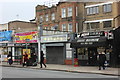
10
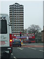
Wyndham Road, SE5
Junction of Camberwell Road and Bowyer Place.
The towerblock is nearby Masterman House.
Image: © Phillip Perry
Taken: 26 Nov 2008
0.06 miles