IMAGES TAKEN NEAR TO
Albany Road, LONDON, SE5 0AW
Introduction
This page details the photographs taken nearby to Albany Road, SE5 0AW by members of the Geograph project.
The Geograph project started in 2005 with the aim of publishing, organising and preserving representative images for every square kilometre of Great Britain, Ireland and the Isle of Man.

There are currently over 7.5m images from over14,400 individuals and you can help contribute to the project by visiting https://www.geograph.org.uk
Image Map
Images are licensed for reuse under creativecommons.org/licenses/by-sa/2.0
Notes
- Clicking on the map will re-center to the selected point.
- The higher the marker number, the further away the image location is from the centre of the postcode.
Image Listing (195 Images Found)
Images are licensed for reuse under creativecommons.org/licenses/by-sa/2.0
Image
Details
Distance
1

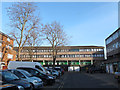
Site of former St Stephen's church, Villa Street, Walworth
Villa Street runs north-south for 400 metres through Walworth. Comparison with old maps shows that this open area near the southern end of the street was the site of St Stephen's Anglican church, a large church (allegedly seating 2000, but such figures are to be taken with a pinch of salt), built c.1866 (architect H Jarvis) and demolished c.1956.
Image: © Stephen Craven
Taken: 14 Apr 2015
0.01 miles
2
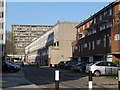
Dead end of Villa Street, Walworth
Villa Street runs north-south for 400 metres through Walworth. Starting with 19th century and then early 20th century housing at the north end, it progresses to these less attractive late 20th century blocks at the southern end. Before redevelopment the street ran through to Albany Road; now there is only a narrow pedestrian route through.
Image: © Stephen Craven
Taken: 14 Apr 2015
0.01 miles
3
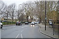
Pedestrian crossing, Albany Road
The crossing over the B214 provide access to the Park Life Cafe on the edge of Burgess Park (right).
Image: © Derek Harper
Taken: 17 Oct 2011
0.03 miles
5
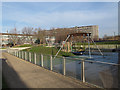
Playground in Burgess Park
The playground is adjacent to the cafe Image
Image: © Stephen Craven
Taken: 10 Dec 2011
0.06 miles
6
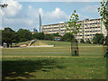
Burgess Park, manmade knoll and bank slide
One of the geometric knolls on the north side of the park has a long path up its ridge with a slide down the short slope into the new play area. In the background is a slab of the Aylesbury estate and, beyond it, the Shard near London Bridge station.
Image: © Robin Stott
Taken: 25 Aug 2013
0.07 miles
7
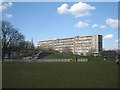
New play area in Burgess Park, Walworth, south London
The triangular mound (easily shaped with earth-moving machinery) supports a slide and cunningly screens the site from Albany Road and a car park. In the background, catching the sun, is Wendover, the most northeasterly of the high slabs of flats on the Aylesbury Estate Image The Shard is also in view (true of many places now).
Image: © Robin Stott
Taken: 5 Apr 2016
0.07 miles
8
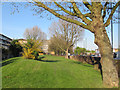
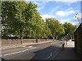
Grass verge, Albany Road
There were once terraced houses along here. The redevelopment of the area in the 1960s set the new housing blocks back from the road, leaving room for a wide verge.
Image: © Stephen Craven
Taken: 14 Apr 2015
0.07 miles
9
Beaconsfield Road, Walworth
Low- and medium-rise housing in the foreground, with a high-rise block on Thurlow Street beyond.
Image: © Stephen Craven
Taken: 14 Apr 2015
0.07 miles
10
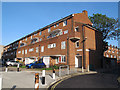
Gaitskell House, Beaconsfield Road, Walworth
This appears to be more recent, and more attractive, housing than the 1970s buildings on the estate.
Image: © Stephen Craven
Taken: 14 Apr 2015
0.08 miles