IMAGES TAKEN NEAR TO
Arica Road, LONDON, SE4 2PZ
Introduction
This page details the photographs taken nearby to Arica Road, SE4 2PZ by members of the Geograph project.
The Geograph project started in 2005 with the aim of publishing, organising and preserving representative images for every square kilometre of Great Britain, Ireland and the Isle of Man.

There are currently over 7.5m images from over14,400 individuals and you can help contribute to the project by visiting https://www.geograph.org.uk
Image Map
Images are licensed for reuse under creativecommons.org/licenses/by-sa/2.0
Notes
- Clicking on the map will re-center to the selected point.
- The higher the marker number, the further away the image location is from the centre of the postcode.
Image Listing (90 Images Found)
Images are licensed for reuse under creativecommons.org/licenses/by-sa/2.0
Image
Details
Distance
1
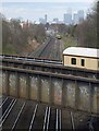
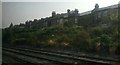
Railways, Brockley
From a footbridge linking Dalrymple and Turnham Roads, a view across the railway line to Crofton Park Station as it, too, crosses the line between Honor Oak Park and Brockley. Canary Wharf in the distance.
Image: © Derek Harper
Taken: 11 Mar 2011
0.09 miles
2
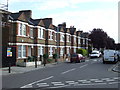
Revelon Road, Brockley
Revelon Road, a street of terraced housing in Brockley, South East London.
Image: © Malc McDonald
Taken: 29 Jun 2011
0.11 miles
3
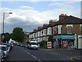
St. Asaph Road, Brockley
St. Asaph Road in Brockley, South East London.
Image: © Malc McDonald
Taken: 29 Jun 2011
0.12 miles
4
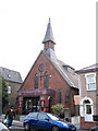
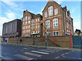
Elim Pentecostal Church, Foxberry Road
This brick building at 76-78 Foxberry Road was built in 1893 by Balham Brothers to the designs of Gilbee Scott. It was originally St George's Anglican church, a daughter church of the parish of St James, Hatcham.
The church was sold in 2003 to the Elim Pentecostal church.
The vacant site to the left is probably where stood the former church hall of 1887, said to be built on the site of a blacksmith's forge.
Image: © Stephen Craven
Taken: 29 Mar 2011
0.12 miles
5
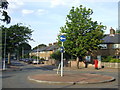
St Norbert Road, SE4
Roundabout at the junction of St Norbert Road with Brockill Crescent, SE4
Image: © Malc McDonald
Taken: 27 Jun 2010
0.13 miles
6
The John Stainer Primary School, and zebra crossing, Brockley
Image: © Ruth Sharville
Taken: 2 Jan 2023
0.13 miles
7
Brockley: houses on Kneller Road, from the railway
Image: © Christopher Hilton
Taken: 22 Jul 2013
0.14 miles
8
MoT station?
The reception area looks a bit of a mess, but perhaps it is just being refitted. The small garage area is round the back.
Image: © Robin Webster
Taken: 30 Oct 2011
0.14 miles
9
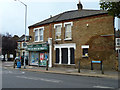
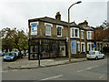
Corner shop, SE4
On the corner of Avignon Road and Aspinall Road.
Image: © Robin Webster
Taken: 30 Oct 2011
0.15 miles
10
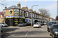
St Asaph Road
Seen at the junction with Dundalk Road, St Asaph Road is part of a network of suburban streets in a triangle of railway lines between Nunhead and Brockley.
Image: © Martin Addison
Taken: 16 Apr 2015
0.15 miles