IMAGES TAKEN NEAR TO
Brockley Way, LONDON, SE4 2LT
Introduction
This page details the photographs taken nearby to Brockley Way, SE4 2LT by members of the Geograph project.
The Geograph project started in 2005 with the aim of publishing, organising and preserving representative images for every square kilometre of Great Britain, Ireland and the Isle of Man.

There are currently over 7.5m images from over14,400 individuals and you can help contribute to the project by visiting https://www.geograph.org.uk
Image Map
Images are licensed for reuse under creativecommons.org/licenses/by-sa/2.0
Notes
- Clicking on the map will re-center to the selected point.
- The higher the marker number, the further away the image location is from the centre of the postcode.
Image Listing (75 Images Found)
Images are licensed for reuse under creativecommons.org/licenses/by-sa/2.0
Image
Details
Distance
1
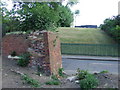
Remains of railway bridge, Merttins Road SE4
The brick wall, and the mound on the opposite side of the road, are a clue that a railway bridge once stood at this point. It carried the Crystal Palace High Level branch across Merttins Road, between Nunhead and Honor Oak stations. The railway line closed in 1954.
Image: © Malc McDonald
Taken: 27 Jun 2010
0.01 miles
2
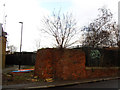
Brickwork at risk from a tree
I thought this was the remains of a building that had once stood on the site, but Malc Macdonald identifies it as the remains of a railway bridge Image it is now in danger of being completely demolished by tree roots. Behind the fence is now an education centre.
Image: © Stephen Craven
Taken: 18 Jan 2015
0.02 miles
3
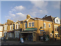
Corner shop, Athenlay Road
The house including a ground floor shop seems to have been rebuilt since 1998 Image but in traditional style.
Image: © Stephen Craven
Taken: 18 Jan 2015
0.02 miles
4
Merttins Road, SE4
The brick wall, and the mound on the opposite side of the road, are a clue that a railway bridge once stood at this point. It carried the Crystal Palace High Level branch which closed in 1954.
Image: © Malc McDonald
Taken: 27 Jun 2010
0.03 miles
5
Merttins Road, SE4
The brick wall, and the mound on the opposite side of the road, are a clue that a railway bridge once stood at this point. It carried the Crystal Palace High Level branch which closed in 1954.
Image: © Malc McDonald
Taken: 27 Jun 2010
0.03 miles
6
New houses on Ivydale Road (3)
The backs of these houses reveal the solar panels mounted above dormer windows.
Image: © Stephen Craven
Taken: 18 Jan 2015
0.03 miles
7
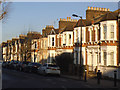
Terraced houses, Athenlay Road
Typical of the larger late 19th century terraces in this part of London. With up to eight chimney pots per house, the roofscape is quite striking.
Image: © Stephen Craven
Taken: 18 Jan 2015
0.04 miles
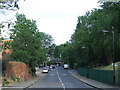
8
On the Nunhead Footpath
This ancient footpath runs from Brockley to Nunhead. This photo was taken on Merttins Road near the corner with Athenlay Road looking towards Brenchley Gardens. Near the centre of the picture can be seen the abutments for the old railway bridge that carried the line running to Crystal Palace High Level which closed in about 1953.
Image: © David Wright
Taken: 6 Sep 1998
0.04 miles
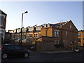
9
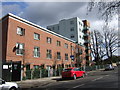
Building on Brockley Way
New houses and flats on Brockley Way and at the junction with St Norbert Road.
Image: © Derek Harper
Taken: 11 Mar 2011
0.04 miles
10
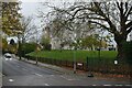
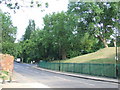
Former railway embankment beside Brenchley Gardens
Not to be mistaken for just any grassy embankment, this was part of the railway route between Nunhead and the former Crystal Palace High Level Station.
Image: © David Martin
Taken: 27 Nov 2022
0.04 miles