IMAGES TAKEN NEAR TO
Brockley Way, LONDON, SE4 2LJ
Introduction
This page details the photographs taken nearby to Brockley Way, SE4 2LJ by members of the Geograph project.
The Geograph project started in 2005 with the aim of publishing, organising and preserving representative images for every square kilometre of Great Britain, Ireland and the Isle of Man.

There are currently over 7.5m images from over14,400 individuals and you can help contribute to the project by visiting https://www.geograph.org.uk
Image Map
Images are licensed for reuse under creativecommons.org/licenses/by-sa/2.0
Notes
- Clicking on the map will re-center to the selected point.
- The higher the marker number, the further away the image location is from the centre of the postcode.
Image Listing (130 Images Found)
Images are licensed for reuse under creativecommons.org/licenses/by-sa/2.0
Image
Details
Distance
1
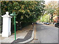
Green Chain Walk on Brockley Way
The long distance path leads left into Camberwell New Cemetery (and onwards to Honor Oak), it also heads straight along Brockley Way towards Nunhead Cemetery (and onwards to Nunhead Railway Station).
Image: © David Anstiss
Taken: 25 Sep 2011
0.02 miles
2
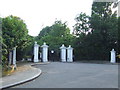
Cemetery gates, Brockley
Entrance to Camberwell New Cemetery on Brockley Way.
Image: © Malc McDonald
Taken: 27 Jun 2010
0.03 miles
3
Railway bridge, Brockley
Pedestrian and cyclists' bridge linking Brockley Way with Eddystone Road.
Image: © Malc McDonald
Taken: 27 Jun 2010
0.04 miles
4
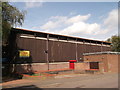
Honor Oak Youth Club
On Turnham Road.
Image: © David Anstiss
Taken: 25 Sep 2011
0.05 miles
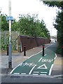
5
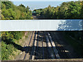
Cycle bridge over main line railway
This footbridge joins Eddystone Road on the east side with Brockley Way on the west, over the London-Brighton main line. The cycle lane was introduced circa 2007.
Image: © Stephen Craven
Taken: 8 Jun 2008
0.05 miles
6
Bridge over main East Croydon - London Bridge line
This looks like a cable bridge, and not very old. In the distance are buildings at Canary Wharf.
Image: © Robin Webster
Taken: 1 Oct 2011
0.07 miles
7
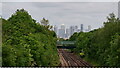
View Towards Canary Wharf
Seen from the footbridge at the end of Eddystone Road.
Image: © Peter Trimming
Taken: 23 May 2023
0.07 miles
8
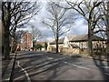
Brockley Way, SE4
In the northwestern corner of the square; the red flats ahead are in Image
Image: © Derek Harper
Taken: 11 Mar 2011
0.08 miles
9
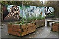
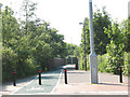
Planters and wildlife mural at Buckthorne Bridge
Image: © David Martin
Taken: 27 Nov 2022
0.09 miles
10
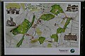
Brockley Three Peaks Walk map
A five mile local walking route taking in One Tree Hill, Hilly Fields and Blythe Hill Fields. It confusingly, and incorrectly, features in some websites as the "Brockley Three Parks Walk". Map designed by Lynda Durrant https://fullcircle-design.co.uk/maps/
Image: © David Martin
Taken: 27 Nov 2022
0.10 miles