IMAGES TAKEN NEAR TO
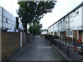
St. Norbert Road, LONDON, SE4 2LG
Introduction
This page details the photographs taken nearby to St. Norbert Road, SE4 2LG by members of the Geograph project.
The Geograph project started in 2005 with the aim of publishing, organising and preserving representative images for every square kilometre of Great Britain, Ireland and the Isle of Man.

There are currently over 7.5m images from over14,400 individuals and you can help contribute to the project by visiting https://www.geograph.org.uk
Image Map
Images are licensed for reuse under creativecommons.org/licenses/by-sa/2.0
Notes
- Clicking on the map will re-center to the selected point.
- The higher the marker number, the further away the image location is from the centre of the postcode.
Image Listing (73 Images Found)
Images are licensed for reuse under creativecommons.org/licenses/by-sa/2.0
Image
Details
Distance
1
Aldersford Close, SE4
Housing built on the site of a disused railway. The branch line from Nunhead to Crystal Palace High Level passed this point, until its closure in 1954.
Image: © Malc McDonald
Taken: 27 Jun 2010
0.05 miles
2
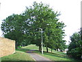
Route of the Crystal Palace High Level branch
The railway line from Nunhead to Crystal Palace High Level once passed through this point. The line was closed in 1954, and a housing development with landscaping occupies this part of the route.
Image: © Malc McDonald
Taken: 27 Jun 2010
0.06 miles
3
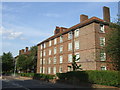
Flats on St Norbert Road, SE4
Local authority flats in Brockley.
Image: © Malc McDonald
Taken: 27 Jun 2010
0.08 miles
4

Remains of St Silas church, Nunhead
The garden of the present church Image contains remains of the former church on the site Image including the font and war memorial.
Image: © Stephen Craven
Taken: 8 Oct 2008
0.09 miles
5
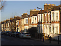
Terraced houses, Athenlay Road
Typical of the larger late 19th century terraces in this part of London. With up to eight chimney pots per house, the roofscape is quite striking.
Image: © Stephen Craven
Taken: 18 Jan 2015
0.10 miles
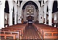
6
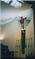
Interior of St Antony's church
The interior of Image, showing not only the crucifix above the altar but also the unusual drapes or 'sails' hanging from the roof in place of a conventional ceiling.
Image: © Stephen Craven
Taken: 22 Sep 2004
0.10 miles
7

Church of St Antony and St Silas
This church, opened in 2003, was built on the site of Image - the site sits astride the grid line, but this photo is from the north-west. It also replaced St Antony's church, now Image, hence the dual name.
Image: © Stephen Craven
Taken: 26 Aug 2008
0.10 miles
10
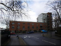
Cooper House, Brockley Way
One wing of a three-winged block.
Image: © Stephen Craven
Taken: 18 Jan 2015
0.10 miles