IMAGES TAKEN NEAR TO
St. Asaph Road, LONDON, SE4 2EE
Introduction
This page details the photographs taken nearby to St. Asaph Road, SE4 2EE by members of the Geograph project.
The Geograph project started in 2005 with the aim of publishing, organising and preserving representative images for every square kilometre of Great Britain, Ireland and the Isle of Man.

There are currently over 7.5m images from over14,400 individuals and you can help contribute to the project by visiting https://www.geograph.org.uk
Image Map
Images are licensed for reuse under creativecommons.org/licenses/by-sa/2.0
Notes
- Clicking on the map will re-center to the selected point.
- The higher the marker number, the further away the image location is from the centre of the postcode.
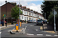
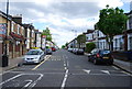
Image Listing (156 Images Found)
Images are licensed for reuse under creativecommons.org/licenses/by-sa/2.0
Image
Details
Distance
1
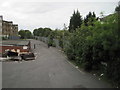
Nunhead 1st railway station (site), Greater London
Opened in 1872 by the London Chatham & Dover Railway on its branch from Peckham Rye to Greenwich Park, this station closed in 1925. It was replaced by a new station on the west side of Gibbon Road.
View west towards the later station and Peckham Rye. The 1872 station had one platform to the left of where the fence now is and one to the right, behind the shrubbery. The current railway layout is entirely to the right of the fence.
Image: © Nigel Thompson
Taken: 18 Sep 2016
0.01 miles
2
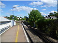
Nunhead station
Nunhead station was opened on 18th September 1871, although the line through here had been opened on 1st August 1865 by the London, Chatham & Dover Railway when the original Crystal Palace & South London Junction Railway line from Brixton to Crystal Palace (High Level) began operation. The line was built to take passengers to the Crystal Palace exhibition site. The Nunhead to Greenwich Park line was opened in 1871 as far as Blackheath Hill on the same day as Nunhead station, with the final stretch to Greenwich Park coming into use in 1888. The Catford Loop line came into operation on 1st July 1892. It gave a second route out of London for the LCDR, and Nunhead thus became a three way junction. In 1925, the lines in the area were electrified, and a new station at Nunhead was built on the London side of the original site. In 1954 the line to Crystal Palace (High Level) was closed but the other lines still operate, although the line to Greenwich Park now runs only as far as Lewisham. This view looks down the line towards Lewisham or the Catford Loop. The Crystal Palace (High Level) branch used to veer off to the right just beyond the curve.
Image: © Marathon
Taken: 24 Aug 2011
0.02 miles
5
Hathway Terrace, Kitto Road, New Cross
Image: © Chris Whippet
Taken: 1 Mar 2015
0.04 miles
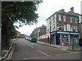
6
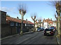
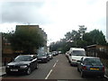
Nunhead: St. Asaph Road
Looking east, with excellent late Victorian terrace houses, that, it must be said, have endured much better than much of the rubbish put up in the 1960s.
Image: © Dr Neil Clifton
Taken: 18 Jun 2012
0.04 miles
8
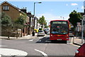
Nunhead: Ivydale Road
Looking southeast with a bus on Central London's route P12.
Image: © Dr Neil Clifton
Taken: 18 Jun 2012
0.05 miles
10
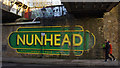
Nunhead station - Walk this way
A modern painted sign on the Gibbon Road bridge abutment.
Image: © Ian Taylor
Taken: 18 Jan 2020
0.06 miles