IMAGES TAKEN NEAR TO
Tressillian Road, LONDON, SE4 1YB
Introduction
This page details the photographs taken nearby to Tressillian Road, SE4 1YB by members of the Geograph project.
The Geograph project started in 2005 with the aim of publishing, organising and preserving representative images for every square kilometre of Great Britain, Ireland and the Isle of Man.

There are currently over 7.5m images from over14,400 individuals and you can help contribute to the project by visiting https://www.geograph.org.uk
Image Map
Images are licensed for reuse under creativecommons.org/licenses/by-sa/2.0
Notes
- Clicking on the map will re-center to the selected point.
- The higher the marker number, the further away the image location is from the centre of the postcode.
Image Listing (35 Images Found)
Images are licensed for reuse under creativecommons.org/licenses/by-sa/2.0
Image
Details
Distance
1
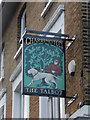
The Talbot pub sign, St Johns
This is the sign hanging outside the Talbot, a fine Victorian pub on Tyrwhitt Road.
Image: © Stephen McKay
Taken: 1 Dec 2018
0.17 miles
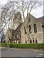
2
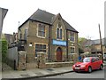
St.Gregorios Indian Orthodox Church, Brockley
"The Indian Orthodox Church is also known as Malankara Orthodox Syrian Church, a Church founded by St Thomas, one of the twelve apostles of Jesus Christ, who came to India in AD 52" http://www.indian-orthodox.co.uk/ . For the life of St.Gregorios (Parumala Thirumeni), see http://en.wikipedia.org/wiki/Gheevarghese_Mar_Gregorios_of_Parumala .
The building is mapped as St Peter's Hall; Image is almost opposite.
Image: © Derek Harper
Taken: 11 Mar 2011
0.17 miles
3
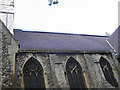
Photovoltaic panels, St Peter's church
These panels were installed in 2006 on the south-facing roof of Image
Image: © Stephen Craven
Taken: 7 Sep 2006
0.17 miles
4
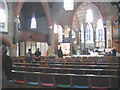
Interior of St Peter's church
The church Image was reordered in 2006, with new seating and lighting, and solar powered water heating Image
Image: © Stephen Craven
Taken: 7 Sep 2006
0.18 miles
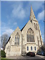
5
Church of St Peter, Brockley
Also shown in http://www.geograph.org.uk/search.php?i=21330716 and seen here from Cranfield Road. The church was built in the 1860s but the octagon at the top of the tower was added in 1890 http://www.britishlistedbuildings.co.uk/en-203434-church-of-st-peter-lewisham .
Image: © Derek Harper
Taken: 11 Mar 2011
0.18 miles
6
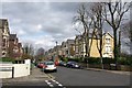
Tressillian Road, SE4
A view northwards from the junction shown in Image The semi-detached houses in this conservation area are discussed on page 13 of http://www.lewisham.gov.uk/NR/rdonlyres/979A6EA4-9C2A-466B-940E-962077E79D68/0/BrockleyCAA4_1334.pdf .
Image: © Derek Harper
Taken: 11 Mar 2011
0.19 miles
8
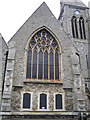
South end of St John's church
This Grade II church at the corner of St John's Vale and Lewisham Way has a very tall spire and is surrounded by trees, so difficult to photograph in its entirety. Here is the south ('back') end of the church with three new small windows inserted below the original main window when the church was reordered in the 1970's.
Image: © Stephen Craven
Taken: 23 Aug 2006
0.19 miles
9
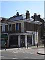
Disused fruit and vegetable shop, Loampit Hill SE4
At the junction with Tyrwhitt Road SE4. Taken from Lewisham Way SE4 (Lewisham Way become Loampit Hill at this junction)
Image: © Robin Sones
Taken: 8 Apr 2010
0.20 miles
10
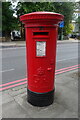
George V postbox on Loampit Hill (A20)
Postbox No. SE13 6.
Image: © JThomas
Taken: 24 Jun 2022
0.21 miles