IMAGES TAKEN NEAR TO
Dressington Avenue, LONDON, SE4 1JF
Introduction
This page details the photographs taken nearby to Dressington Avenue, SE4 1JF by members of the Geograph project.
The Geograph project started in 2005 with the aim of publishing, organising and preserving representative images for every square kilometre of Great Britain, Ireland and the Isle of Man.

There are currently over 7.5m images from over14,400 individuals and you can help contribute to the project by visiting https://www.geograph.org.uk
Image Map
Images are licensed for reuse under creativecommons.org/licenses/by-sa/2.0
Notes
- Clicking on the map will re-center to the selected point.
- The higher the marker number, the further away the image location is from the centre of the postcode.
Image Listing (137 Images Found)
Images are licensed for reuse under creativecommons.org/licenses/by-sa/2.0
Image
Details
Distance
1
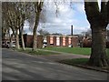
Ladywell Centre
"A day service for people with disabilities and sensory impairments aged 18 and above" http://www.horizones.org.uk/ladywell-centre.htm
Image: © Derek Harper
Taken: 11 Mar 2011
0.03 miles
2
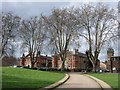
Ladywell Lodge
These two blocks, with a connecting block out of sight, are the remnants of the Bermondsey Union Workhouse, dating from 1900, and now flats. On the right, behind Image, is Image
Image: © Derek Harper
Taken: 11 Mar 2011
0.05 miles
3
View of the railway crossing the Ravensbourne #2
Looking north-northeast.
Image: © Robert Lamb
Taken: 25 Nov 2011
0.07 miles
4
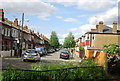
View of Malyons Road from Ladywell Fields
Looking north-northeast.
Image: © Robert Lamb
Taken: 25 Nov 2011
0.07 miles
5
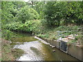
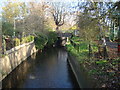
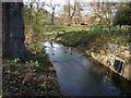
The River Ravensbourne in Ladywell Fields (9)
The River Ravensbourne formerly ran along the eastern edge of the park, hidden behind railings and dense vegetation. The concrete channel is still there in places, but new meanders have been created, running some of the water through the middle of the park - see http://www.therrc.co.uk/case_studies/ladywell_fields.pdf.
Image: © Mike Quinn
Taken: 5 Aug 2009
0.07 miles
6
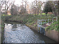
Drainage outfall into the River Ravensbourne
Image: © Stephen Craven
Taken: 26 Dec 2009
0.07 miles
7
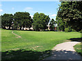
Ladywell Fields, west of the river
Looking up the low rise west of the Ravensbourne.
Image: © Stephen Craven
Taken: 24 Jul 2011
0.07 miles
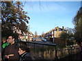
10
View of the Ravensbourne from the footbridge near Malyons Road
Looking west-southwest.
Image: © Robert Lamb
Taken: 25 Nov 2011
0.08 miles