IMAGES TAKEN NEAR TO
Tilbrook Road, LONDON, SE3 9QD
Introduction
This page details the photographs taken nearby to Tilbrook Road, SE3 9QD by members of the Geograph project.
The Geograph project started in 2005 with the aim of publishing, organising and preserving representative images for every square kilometre of Great Britain, Ireland and the Isle of Man.

There are currently over 7.5m images from over14,400 individuals and you can help contribute to the project by visiting https://www.geograph.org.uk
Image Map
Images are licensed for reuse under creativecommons.org/licenses/by-sa/2.0
Notes
- Clicking on the map will re-center to the selected point.
- The higher the marker number, the further away the image location is from the centre of the postcode.
Image Listing (33 Images Found)
Images are licensed for reuse under creativecommons.org/licenses/by-sa/2.0
Image
Details
Distance
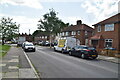
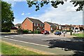
9
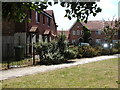
Nelson Mandela Road
A new housing development just off Rochester Way
Image: © David Hatch
Taken: 18 Jun 2005
0.12 miles
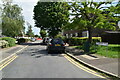
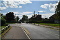
10
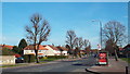
Rochester Way, Kidbrooke
Rochester Way used to be the route of the A2 trunk road from Dover, Canterbury and the Medway Towns to London. A relief road was opened in the 1980s taking much of the traffic away from Rochester Way.
This image was taken on a sunny March day. At this time of year, the trees are still bare from winter.
Image: © Malc McDonald
Taken: 15 Mar 2014
0.14 miles