IMAGES TAKEN NEAR TO
Astell Road, LONDON, SE3 9FB
Introduction
This page details the photographs taken nearby to Astell Road, SE3 9FB by members of the Geograph project.
The Geograph project started in 2005 with the aim of publishing, organising and preserving representative images for every square kilometre of Great Britain, Ireland and the Isle of Man.

There are currently over 7.5m images from over14,400 individuals and you can help contribute to the project by visiting https://www.geograph.org.uk
Image Map
Images are licensed for reuse under creativecommons.org/licenses/by-sa/2.0
Notes
- Clicking on the map will re-center to the selected point.
- The higher the marker number, the further away the image location is from the centre of the postcode.
Image Listing (119 Images Found)
Images are licensed for reuse under creativecommons.org/licenses/by-sa/2.0
Image
Details
Distance
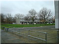
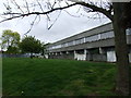
1
Ferrier Estate, Kidbrooke
Awaiting regeneration.
Image: © Chris Whippet
Taken: 27 Apr 2009
0.01 miles
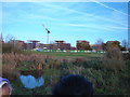
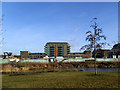
2
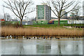
'This building is being demolished early 2012 as part of the Kidbrooke Regeneration'
Looking across a frozen pond in Sutcliffe Park.
Image: © Robin Webster
Taken: 4 Feb 2012
0.01 miles
3
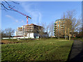
Kidbrooke Village: development in progress
New housing blocks being built on the north side of Tudway Road.
Image: © Stephen Craven
Taken: 24 Jan 2015
0.02 miles
4
Ferrier Estate, Kidbrooke
Built in 1974, the area is now awaiting regeneration.
Image: © Chris Whippet
Taken: 27 Apr 2009
0.03 miles
5
View of the Kidbrooke Village urban development from Sutcliffe Park #2
Looking north-northwest.
Image: © Robert Lamb
Taken: 26 Nov 2011
0.05 miles
6
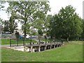
Flood defences under Tudway Road, SE3 (2)
On the northern edge of Sutcliffe Park through which the Quaggy River flows.
Image: © Mike Quinn
Taken: 2 Sep 2010
0.05 miles
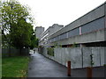
7
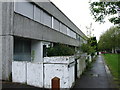
Tudway Road, Ferrier Estate, Kidbrooke
Image: © Chris Whippet
Taken: 27 Apr 2009
0.05 miles
8
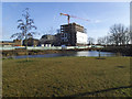
Kidbrooke Village: new phase starting
In the distance is one large housing block already completed on the west side of Tudway Road; between that and the pond further construction work was still at demolition stage.
It is difficult to compare old photos with new in this estate with great precision, as the whole area is being completely transformed, but this is roughly the area between Cambert Way and Romero Square in the former Kidbrooke Estate. See Image for a view in nearly the same location barely five years earlier.
Image: © Stephen Craven
Taken: 24 Jan 2015
0.06 miles
9
Kidbrooke Village: Cator Park
This new pond forms part of Cator Park, a linear park in the redeveloped Kidbrooke estate, and is on the site of the former Cambert Way.
Image: © Stephen Craven
Taken: 24 Jan 2015
0.06 miles