IMAGES TAKEN NEAR TO
Handley Drive, LONDON, SE3 9ET
Introduction
This page details the photographs taken nearby to Handley Drive, SE3 9ET by members of the Geograph project.
The Geograph project started in 2005 with the aim of publishing, organising and preserving representative images for every square kilometre of Great Britain, Ireland and the Isle of Man.

There are currently over 7.5m images from over14,400 individuals and you can help contribute to the project by visiting https://www.geograph.org.uk
Image Map
Images are licensed for reuse under creativecommons.org/licenses/by-sa/2.0
Notes
- Clicking on the map will re-center to the selected point.
- The higher the marker number, the further away the image location is from the centre of the postcode.
Image Listing (104 Images Found)
Images are licensed for reuse under creativecommons.org/licenses/by-sa/2.0
Image
Details
Distance
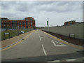
1
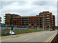
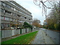
Halton Court, Kidbrooke
One of the first new blocks to be completed in the new Kidbrooke Village.
Image: © Stephen Craven
Taken: 31 Jul 2014
0.01 miles
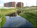
2
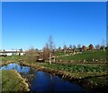
Cator Park, Kidbrooke
This lake is part of the new Kidbrooke Village development on the site of the former Ferrier Estate. The park here has been named Cator Park after the nearby Cator Estate at Blackheath Park but this is a little confusing as there is also a Cator Park at Beckenham - see http://www.geograph.org.uk/photo/2404836
Clearly the developers preferred the name of the park to be linked to the very much upmarket Blackheath Park, rather than what was here before. See also https://www.geograph.org.uk/photo/4127103
Image: © Marathon
Taken: 22 Jan 2021
0.04 miles
3
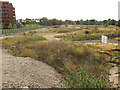
Kidbrooke, awaiting redevelopment
The former buildings around Ebdon Way (foreground) and Gallus Square Image were demolished some time ago, and nothing has happened since Image a few months earlier.
Image: © Stephen Craven
Taken: 5 Aug 2014
0.04 miles
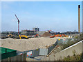
4
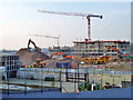
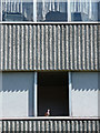
Demolition and construction, Kidbrooke
The 1960s concept of urban high density housing is replaced with the 2010s approach. All profit for the contractors and their associates.
Image: © Robin Webster
Taken: 4 Feb 2012
0.05 miles
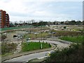
5
Ensign Street, Kidbrooke
One of the new road alignments in the still-being-developed Kidbrooke Village, this is about 50m south of the previous Lebrun Square.
Image: © Stephen Craven
Taken: 31 Jul 2014
0.05 miles
6
Cator Park at Kidbrooke Village
This lake is part of the new Kidbrooke Village development on the site of the former Ferrier Estate. The park here has been named Cator Park after the nearby Cator Estate at Blackheath Park but this is a little confusing as there is also a Cator Park at Beckenham - see http://www.geograph.org.uk/photo/2404836
Clearly the developers preferred the name of the park to be linked to the very much upmarket Blackheath Park, rather than what was here before. It all looks very new and tidy at the moment.
Image: © Marathon
Taken: 16 Aug 2014
0.06 miles
7
Demolition and construction, Kidbrooke
The 1960s concept of urban high density housing is replaced with the 2010s approach. All profit for the contractors and their associates.
Image: © Robin Webster
Taken: 4 Feb 2012
0.06 miles
10
Pigeon, Ferrier Estate
The human residents having been moved out prior to demolition, rats and pigeons had spotted an opportunity and colonised the place. This pigeon was surveying the view from his/her spacious new open-plan, split-level, net-curtained apartment which had been going for a song. I didn't envy him/her the noisy pair of love birds upstairs.
Image: © Stephen Richards
Taken: 1 Apr 2012
0.07 miles