IMAGES TAKEN NEAR TO
Guy Barnett Grove, LONDON, SE3 9AL
Introduction
This page details the photographs taken nearby to Guy Barnett Grove, SE3 9AL by members of the Geograph project.
The Geograph project started in 2005 with the aim of publishing, organising and preserving representative images for every square kilometre of Great Britain, Ireland and the Isle of Man.

There are currently over 7.5m images from over14,400 individuals and you can help contribute to the project by visiting https://www.geograph.org.uk
Image Map
Images are licensed for reuse under creativecommons.org/licenses/by-sa/2.0
Notes
- Clicking on the map will re-center to the selected point.
- The higher the marker number, the further away the image location is from the centre of the postcode.
Image Listing (52 Images Found)
Images are licensed for reuse under creativecommons.org/licenses/by-sa/2.0
Image
Details
Distance
1

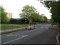
Casterbridge Estate, Kidbrooke
Two of the seven blocks built around an ornamental pond. With Casterbridge Road in the foreground.
Image: © Derek Harper
Taken: 20 May 2006
0.06 miles
2
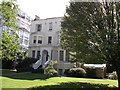
102 Manorbrook,
A Grade II listed building on Manor Way near Manorbrook.
Within the private Blackheath Cator Estate.
See http://www.britishlistedbuildings.co.uk/en-200449-102-eltham for more details about the building.
Image: © David Anstiss
Taken: 11 Sep 2011
0.07 miles
3
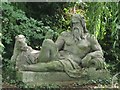
Sculpture in the lake in gardens east of Brooklands Park, SE3
The location of this statue is shown in Image I am grateful to Melvyn Harrison, Chairman of the Crystal Palace Foundation http://www.crystalpalacefoundation.org.uk/ , for the information that this statue of a reclining man is one of several similar ones that were commissioned by Sir Joseph Paxton http://en.wikipedia.org/wiki/Joseph_Paxton in 1854 for setting in the grounds of the Crystal Palace at Sydenham; it was sculpted by Raffaele Monti http://en.wikipedia.org/wiki/Raffaelle_Monti. For further details, please see the Sydenham Town Forum website http://www.sydenham.org.uk/forum/viewtopic.php?f=10&t=3407&sid=8d8ab530250172341f4aeb6931c77dba.
Image: © Mike Quinn
Taken: 2 Sep 2010
0.07 miles
4
Pond in Blackheath
A natural oasis in Blackheath.
Image: © Alan Hughes
Taken: 19 Jan 2020
0.07 miles
5
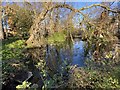
Brooklands Park / Castlebridge Road, SE3
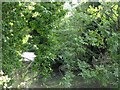
The low stone wall (left) marks where the Middle Kid Brook passes under the road. It then flows along the line of Image
Image: © Mike Quinn
Taken: 2 Sep 2010
0.08 miles
6
Lake in gardens east of Brooklands Park, SE3
Middle Kid Brook flows through this lake. Shows the location of Image
Image: © Mike Quinn
Taken: 2 Sep 2010
0.08 miles
7
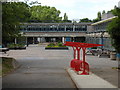
Thomas Tallis Secondary School, Kidbrooke Park Road
Built in the 1970s the fabric of the school is falling apart and will be replaced with a new building within the next decade. Very much a multi-ethnic inner London school, it is also extremely popular with parents over quite a radius and achieves excellent academic results
Image: © David Hatch
Taken: 18 Jun 2005
0.08 miles
8
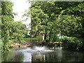
Lake in gardens east of Brooklands Park, SE3 (2)
Middle Kid Brook flows through this lake.
Image: © Mike Quinn
Taken: 2 Sep 2010
0.08 miles
10
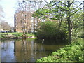
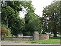
Brooklands Pond
Not easy to find within Blackheath Park without a map, Brooklands Pond lies next to Brooklands Park and is encircled by Castlebridge Road.
Image: © Marathon
Taken: 8 Apr 2011
0.08 miles