IMAGES TAKEN NEAR TO
Casterbridge Road, LONDON, SE3 9AD
Introduction
This page details the photographs taken nearby to Casterbridge Road, SE3 9AD by members of the Geograph project.
The Geograph project started in 2005 with the aim of publishing, organising and preserving representative images for every square kilometre of Great Britain, Ireland and the Isle of Man.

There are currently over 7.5m images from over14,400 individuals and you can help contribute to the project by visiting https://www.geograph.org.uk
Image Map (Loading...)


Getting Data...Please wait
Leaflet Map data © OpenStreetMap
Images are licensed for reuse under creativecommons.org/licenses/by-sa/2.0
Notes
- Clicking on the map will re-center to the selected point.
- The higher the marker number, the further away the image location is from the centre of the postcode.
Image Listing (55 Images Found)
Images are licensed for reuse under creativecommons.org/licenses/by-sa/2.0
Image
Details
Distance
2
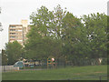
Playground on Moorhead Way
One of the play facilities on the doomed Kidbrooke Estate - see Image
Image: © Stephen Craven
Taken: 9 May 2009
0.07 miles
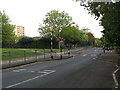
3
Ferrier Estate, Moorehead Way
Soon to be the ex-Ferrier Estate. Much of it has already been turned to dust, to be supplanted by a more modern experiment. The estate was built by the Greater London Council and completed in 1970.
Image: © Stephen Richards
Taken: 1 Apr 2012
0.07 miles
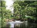
5
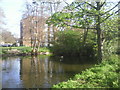
Brooklands Pond
Not easy to find within Blackheath Park without a map, Brooklands Pond lies next to Brooklands Park and is encircled by Castlebridge Road.
Image: © Marathon
Taken: 8 Apr 2011
0.08 miles
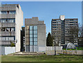
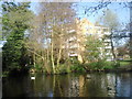
6

Casterbridge Estate, Kidbrooke
Two of the seven blocks built around an ornamental pond. With Casterbridge Road in the foreground.
Image: © Derek Harper
Taken: 20 May 2006
0.09 miles
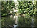
7
Brooklands Pond, Blackheath Park
Not easy to find without a map, Brooklands Pond lies next to Brooklands Park and is encircled by Castlebridge Road.
Image: © Marathon
Taken: 8 Apr 2011
0.09 miles
8
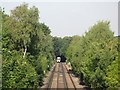
Railway lines northwest of Kidbrooke station
Image: © Mike Quinn
Taken: 2 Sep 2010
0.09 miles
9
Lake in gardens east of Brooklands Park, SE3 (3)
Middle Kid Brook flows through this lake.
Image: © Mike Quinn
Taken: 2 Sep 2010
0.10 miles
10
Lake in gardens east of Brooklands Park, SE3 (2)
Middle Kid Brook flows through this lake.
Image: © Mike Quinn
Taken: 2 Sep 2010
0.10 miles