IMAGES TAKEN NEAR TO
Hervey Road, LONDON, SE3 8RR
Introduction
This page details the photographs taken nearby to Hervey Road, SE3 8RR by members of the Geograph project.
The Geograph project started in 2005 with the aim of publishing, organising and preserving representative images for every square kilometre of Great Britain, Ireland and the Isle of Man.

There are currently over 7.5m images from over14,400 individuals and you can help contribute to the project by visiting https://www.geograph.org.uk
Image Map
Images are licensed for reuse under creativecommons.org/licenses/by-sa/2.0
Notes
- Clicking on the map will re-center to the selected point.
- The higher the marker number, the further away the image location is from the centre of the postcode.
Image Listing (78 Images Found)
Images are licensed for reuse under creativecommons.org/licenses/by-sa/2.0
Image
Details
Distance
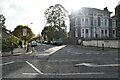
1
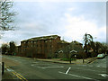
Hider Court, Blackheath
A sheltered housing unit on the corner of Shooters Hill Road and Hervey Road.
Image: © Stephen Craven
Taken: 25 Dec 2012
0.01 miles
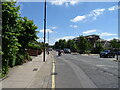
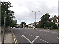
2
Hervey Road, Blackheath
A view along the road from its north-eastern end, junction with Shooters Hill Road.
Image: © Stephen Craven
Taken: 25 Dec 2012
0.03 miles
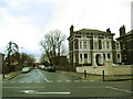
3
Shooters Hill Road (A207)
Looking south east.
Image: © JThomas
Taken: 20 Jun 2022
0.03 miles
4
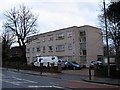
Belgrave Court
A block of privately owned flats on Shooters Hill.
Image: © Stephen Craven
Taken: 25 Dec 2012
0.03 miles
6
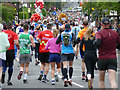
London Marathon 2019 - merged streams
The two streams of runners who set off along Vanbrugh Park and Shooters Hill Road come together here just before the one mile mark, making a particularly densely packed field.
Image: © Stephen Craven
Taken: 28 Apr 2019
0.04 miles
7
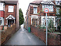
Cut through to Cherry Orchard
A narrow footpath leading from Shooters Hill Road to Rectory Field Crescent.
Image: © Stephen Craven
Taken: 25 Dec 2012
0.04 miles
8
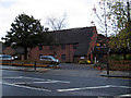
Arnold House
A nursing home on Shooters Hill.
Image: © Stephen Craven
Taken: 25 Dec 2012
0.05 miles
9
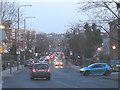
Shooters Hill Road at dusk
Shooters Hill Road follows the alignment of a Roman road, which explains why it runs straight for several miles. This view looking south-east is taken from a junction where the present A207 bends to the west, but the old alignment continues in the opposite direction as Old Dover Road Image
Image: © Stephen Craven
Taken: 24 Jan 2009
0.05 miles
10
Road junction on the A207 Shooters Hill
The A207 leads from Shooters Hill towards Sun-in-the-Sands roundabout.
Old Dover Road leads right towards Vanbrugh Park.
Image: © David Anstiss
Taken: 11 Sep 2011
0.06 miles