IMAGES TAKEN NEAR TO
Mayday Gardens, LONDON, SE3 8NW
Introduction
This page details the photographs taken nearby to Mayday Gardens, SE3 8NW by members of the Geograph project.
The Geograph project started in 2005 with the aim of publishing, organising and preserving representative images for every square kilometre of Great Britain, Ireland and the Isle of Man.

There are currently over 7.5m images from over14,400 individuals and you can help contribute to the project by visiting https://www.geograph.org.uk
Image Map
Images are licensed for reuse under creativecommons.org/licenses/by-sa/2.0
Notes
- Clicking on the map will re-center to the selected point.
- The higher the marker number, the further away the image location is from the centre of the postcode.
Image Listing (88 Images Found)
Images are licensed for reuse under creativecommons.org/licenses/by-sa/2.0
Image
Details
Distance
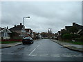
2

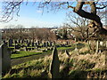
Greenwich Cemetery, Eltham SE9
A view towards the entrance on Well Hall Road, a 10 minute walk straight ahead. Langbrook Road lies a 5 minute walk away behind the photographer, although there is no access out into it. Mayday Gardens - a residential street - is situated behind the tree line on the left. This Victorian cemetery is one of the largest cemeteries in London being of approximately 9.5 hectares in size (or 24 acres) and, as this picture reveals, a considerable amount of spare capacity remains available.
One of half-a-dozen weather-protection shelters is seen here although all but the one nearest the entrance to the cemetery is boarded up as an anti- misbehaviour strategy.
Image: © David Hallam-Jones
Taken: 3 May 2014
0.07 miles
3
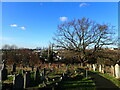
Greenwich Cemetery
Greenwich Cemetery was founded in 1856 by Greenwich Burial Board on a hilly site, with an entrance in Well Hall Road. At the top of the hill are the Commonwealth War Graves and the Heroes Corner and War Memorial. The panoramic views are the finest from any cemetery in London and are some of the best anywhere in London. This view looks towards the towers of Canary Wharf.
Image: © Marathon
Taken: 26 Aug 2022
0.08 miles
4
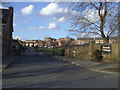
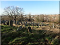
Entrance to Brook Village, Kidbrooke
The name "Brook Village" is misleading: it is actually just a gated housing development in the grounds of the former Brook Hospital. See also Image
Image: © Stephen Craven
Taken: 16 Feb 2014
0.08 miles
5
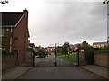
Entrance to Brook Village
Crosier Close leads from Broad Walk (road) into the private housing estate.
This estate was built on the site of the Brook Fever Hospital (demolished in 1990's). It was built by Persminnion Homes as a Millennium project.
Image: © David Anstiss
Taken: 11 Sep 2011
0.08 miles
6
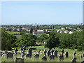
Greenwich Cemetery
Greenwich Cemetery was founded 1856 by Greenwich Burial Board on a hilly site, with an entrance in Well Hall Road. At the top of the hill are the Commonwealth War Graves and the Heroes Corner and War Memorial. The panoramic views are the finest from any cemetery in London and are some of the best anywhere in London.
This is at the top of the hill. The towers of Canary Wharf are right of centre on the horizon while the City of London is slightly to the left of this.
Image: © Marathon
Taken: 25 Jan 2021
0.09 miles
7
Greenwich Cemetery
Greenwich Cemetery was founded 1856 by Greenwich Burial Board on a hilly site, with an entrance in Well Hall Road. At the top of the hill are the Commonwealth War Graves and the Heroes Corner and War Memorial. The panoramic views are the finest from any cemetery in London and are some of the best anywhere in London.
This is at the top of the hill. The towers of Canary Wharf are on the horizon.
Image: © Marathon
Taken: 25 Jan 2021
0.10 miles
8
Greenwich Cemetery
Greenwich Cemetery was founded 1856 by Greenwich Burial Board on a hilly site, with an entrance in Well Hall Road. At the top of the hill are the Commonwealth War Graves and the Heroes Corner and War Memorial. The panoramic views are the finest from any cemetery in London and are some of the best anywhere in London.
This is at the top of the hill. The towers of Canary Wharf are in the centre on the horizon.
Image: © Marathon
Taken: 25 Jan 2021
0.10 miles
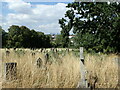
9
The view from Greenwich Cemetery
Greenwich Cemetery was founded 1856 by Greenwich Burial Board on a hilly site, with an entrance in Well Hall Road. At the top of the hill are the Commonwealth War Graves and the Heroes Corner and War Memorial. The panoramic views are the finest from any cemetery in London and are some of the best anywhere in London. This is at the top of the hill. Just left centre can be seen the blocks around Vauxhall, while on the extreme right, the Gherkin is visible.
For more about Greenwich Cemetery see https://londongardenstrust.org/inventory/gardens-online-record.php?ID=GRN026
Image: © Marathon
Taken: 28 May 2020
0.10 miles
10

The view from Greenwich Cemetery
Greenwich Cemetery was founded 1856 by Greenwich Burial Board on a hilly site, with an entrance in Well Hall Road. At the top of the hill are the Commonwealth War Graves and the Heroes Corner and War Memorial. The panoramic views are the finest from any cemetery in London and are some of the best anywhere in London. This is at the top of the hill. In the centre can be seen the blocks around Vauxhall, while further to the right can be seen The Shard.
For more about Greenwich Cemetery see https://londongardenstrust.org/inventory/gardens-online-record.php?ID=GRN026
Image: © Marathon
Taken: 28 May 2020
0.10 miles