IMAGES TAKEN NEAR TO
Kelbrook Road, LONDON, SE3 8LH
Introduction
This page details the photographs taken nearby to Kelbrook Road, SE3 8LH by members of the Geograph project.
The Geograph project started in 2005 with the aim of publishing, organising and preserving representative images for every square kilometre of Great Britain, Ireland and the Isle of Man.

There are currently over 7.5m images from over14,400 individuals and you can help contribute to the project by visiting https://www.geograph.org.uk
Image Map
Images are licensed for reuse under creativecommons.org/licenses/by-sa/2.0
Notes
- Clicking on the map will re-center to the selected point.
- The higher the marker number, the further away the image location is from the centre of the postcode.
Image Listing (75 Images Found)
Images are licensed for reuse under creativecommons.org/licenses/by-sa/2.0
Image
Details
Distance
1
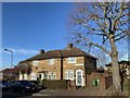
Bournbrook Road
Houses in Bournbrook Road.
Image: © Alan Hughes
Taken: 19 Jan 2020
0.07 miles
2
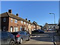
Langbrook Road
Housing in Langbrook Road.
Image: © Alan Hughes
Taken: 19 Jan 2020
0.07 miles
3
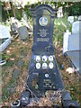
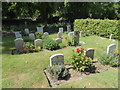
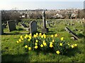
The grave of the Gambardella family in Greenwich Cemetery
Greenwich Cemetery was founded 1856 by Greenwich Burial Board on a hilly site, with an entrance in Well Hall Road. At the top of the hill are the Commonwealth War Graves and the Heroes Corner and War Memorial. The panoramic views are the finest from any cemetery in London and are some of the best anywhere in London. This is at the top of the hill. Just left centre can be seen the blocks around Vauxhall, while on the extreme right, the Gherkin is visible.
For more about Greenwich Cemetery see https://londongardenstrust.org/inventory/gardens-online-record.php?ID=GRN026
This is near the Norwegian section for refugees of the Second World War. It is for the Gambardella family who owned a popular cafe near the Royal Standard at Blackheath.
Image: © Marathon
Taken: 28 May 2020
0.08 miles
4
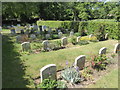
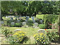
The Norwegian section of Greenwich Cemetery
Greenwich Cemetery was founded 1856 by Greenwich Burial Board on a hilly site, with an entrance in Well Hall Road. At the top of the hill are the Commonwealth War Graves and the Heroes Corner and War Memorial. The panoramic views are the finest from any cemetery in London and are some of the best anywhere in London. This is at the top of the hill. Just left centre can be seen the blocks around Vauxhall, while on the extreme right, the Gherkin is visible.
For more about Greenwich Cemetery see https://londongardenstrust.org/inventory/gardens-online-record.php?ID=GRN026
This is the Norwegian section, dedicated to 30 refugees who were killed during the Second World War. There have been a few subsequent burials here. It is beautifully kept and laid out in a way, similar to the war graves further up the hill - see https://www.geograph.org.uk/photo/6487867
Image: © Marathon
Taken: 28 May 2020
0.09 miles
5
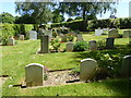
In the Norwegian section of Greenwich Cemetery
Greenwich Cemetery was founded 1856 by Greenwich Burial Board on a hilly site, with an entrance in Well Hall Road. At the top of the hill are the Commonwealth War Graves and the Heroes Corner and War Memorial. The panoramic views are the finest from any cemetery in London and are some of the best anywhere in London. This is at the top of the hill. Just left centre can be seen the blocks around Vauxhall, while on the extreme right, the Gherkin is visible.
For more about Greenwich Cemetery see https://londongardenstrust.org/inventory/gardens-online-record.php?ID=GRN026
This is the Norwegian section, dedicated to 30 refugees who were killed during the Second World War. There have been a few subsequent burials here. It is beautifully kept and laid out in a way, similar to the war graves further up the hill - see https://www.geograph.org.uk/photo/6487867
Image: © Marathon
Taken: 28 May 2020
0.09 miles
6
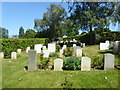
The Norwegian section of Greenwich Cemetery
Greenwich Cemetery was founded 1856 by Greenwich Burial Board on a hilly site, with an entrance in Well Hall Road. At the top of the hill are the Commonwealth War Graves and the Heroes Corner and War Memorial. The panoramic views are the finest from any cemetery in London and are some of the best anywhere in London. This is at the top of the hill. Just left centre can be seen the blocks around Vauxhall, while on the extreme right, the Gherkin is visible.
For more about Greenwich Cemetery see https://londongardenstrust.org/inventory/gardens-online-record.php?ID=GRN026
This is the Norwegian section, dedicated to 30 refugees who were killed during the Second World War. There have been a few subsequent burials here. It is beautifully kept and laid out in a way, similar to the war graves further up the hill - see https://www.geograph.org.uk/photo/6487867
Image: © Marathon
Taken: 28 May 2020
0.09 miles
7
The Norwegian section of Greenwich Cemetery
Greenwich Cemetery was founded 1856 by Greenwich Burial Board on a hilly site, with an entrance in Well Hall Road. At the top of the hill are the Commonwealth War Graves and the Heroes Corner and War Memorial. The panoramic views are the finest from any cemetery in London and are some of the best anywhere in London. This is at the top of the hill. Just left centre can be seen the blocks around Vauxhall, while on the extreme right, the Gherkin is visible.
For more about Greenwich Cemetery see https://londongardenstrust.org/inventory/gardens-online-record.php?ID=GRN026
This is the Norwegian section, dedicated to 30 refugees who were killed during the Second World War. There have been a few subsequent burials here. It is beautifully kept and laid out in a way, similar to the war graves further up the hill - see https://www.geograph.org.uk/photo/6487867
Image: © Marathon
Taken: 28 May 2020
0.10 miles
8
In the Norwegian section of Greenwich Cemetery
Greenwich Cemetery was founded 1856 by Greenwich Burial Board on a hilly site, with an entrance in Well Hall Road. At the top of the hill are the Commonwealth War Graves and the Heroes Corner and War Memorial. The panoramic views are the finest from any cemetery in London and are some of the best anywhere in London. This is at the top of the hill. Just left centre can be seen the blocks around Vauxhall, while on the extreme right, the Gherkin is visible.
For more about Greenwich Cemetery see https://londongardenstrust.org/inventory/gardens-online-record.php?ID=GRN026
This is the Norwegian section, dedicated to 30 refugees who were killed during the Second World War. There have been a few subsequent burials here. It is beautifully kept and laid out in a way, similar to the war graves further up the hill - see https://www.geograph.org.uk/photo/6487867
Image: © Marathon
Taken: 30 May 2020
0.10 miles
9
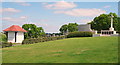
Greenwich Cemetery, Eltham SE9
This picture shows how some of the land on this 9.2 hectare/24 acre site slopes down from its flatter portion (perhaps 50% of it) nearer the Dunblane Road side of the site towards the residential street known as Mayday Gardens. The war memorial cross is one of the central features of the cemetery with two commemorative marble screens and in addition, one of the half-a-dozen (now boarded up) weather-protection shelters is also seen here.
Image: © David Hallam-Jones
Taken: 3 May 2014
0.11 miles
10
Greenwich Cemetery
Greenwich Cemetery was founded 1856 by Greenwich Burial Board on a hilly site, with an entrance in Well Hall Road. At the top of the hill are the Commonwealth War Graves and the Heroes Corner and War Memorial.
The panoramic views are the finest from any cemetery in London and are some of the best anywhere in London. The towers around Canary Wharf can be seen in the centre on the horizon. See also https://www.geograph.org.uk/photo/6487857
Image: © Marathon
Taken: 7 Mar 2021
0.11 miles