IMAGES TAKEN NEAR TO
Glenluce Road, LONDON, SE3 7SB
Introduction
This page details the photographs taken nearby to Glenluce Road, SE3 7SB by members of the Geograph project.
The Geograph project started in 2005 with the aim of publishing, organising and preserving representative images for every square kilometre of Great Britain, Ireland and the Isle of Man.

There are currently over 7.5m images from over14,400 individuals and you can help contribute to the project by visiting https://www.geograph.org.uk
Image Map
Images are licensed for reuse under creativecommons.org/licenses/by-sa/2.0
Notes
- Clicking on the map will re-center to the selected point.
- The higher the marker number, the further away the image location is from the centre of the postcode.
Image Listing (158 Images Found)
Images are licensed for reuse under creativecommons.org/licenses/by-sa/2.0
Image
Details
Distance
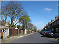
1
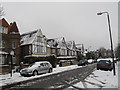
Glenluce Road - upper part
The upper half of Glenluce Road is nearly level, unlike the lower part Image
Image: © Stephen Craven
Taken: 5 Feb 2012
0.02 miles
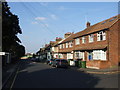
2
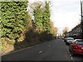
Westcombe Hill, upper section
The section of Westcombe Hill between Kirkside Road and Westcombe Park Road only has houses on the east side. This is a view down the hill.
Image: © Stephen Craven
Taken: 16 Jan 2011
0.03 miles
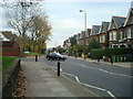
3

Glenluce Road, Blackheath
Some large houses at the top of Glenluce Road. These are now selling for not far off a million pounds.
Image: © Stephen Craven
Taken: 8 Feb 2015
0.03 miles
5
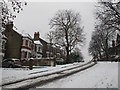
Glenluce Road - lower part
The lower half of Glenluce Road is quite steep (about 1:7 / 15%) and treacherous in the snow.
Image: © Stephen Craven
Taken: 5 Feb 2012
0.05 miles
6
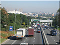
Rush hour on the A102
The tail end of the morning rush hour (9.10am) and traffic is still queueing over 2km from the Blackwall Tunnel northbound entrance. The tunnel entrance itself is close to the O2 Dome (background, left)
Image: © Stephen Craven
Taken: 18 Jul 2006
0.06 miles
8
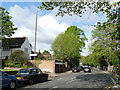
Westcombe Park Road
The sign to the "Church of England Parish Church" (St George's) is a recent addition.
Image: © Stephen Craven
Taken: 28 Apr 2019
0.08 miles
9
Siebert Road
A minor road, with houses on the east side, and garages on the west side belonging to the large houses on Westcombe Hill.
Image: © Stephen Craven
Taken: 13 Apr 2014
0.08 miles
10
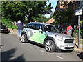
Olympic transport
One of the official cars for the 2012 Games.
Image: © Stephen Craven
Taken: 21 Jul 2012
0.09 miles