IMAGES TAKEN NEAR TO
Langton Way, LONDON, SE3 7JS
Introduction
This page details the photographs taken nearby to Langton Way, SE3 7JS by members of the Geograph project.
The Geograph project started in 2005 with the aim of publishing, organising and preserving representative images for every square kilometre of Great Britain, Ireland and the Isle of Man.

There are currently over 7.5m images from over14,400 individuals and you can help contribute to the project by visiting https://www.geograph.org.uk
Image Map (Loading...)


Getting Data...Please wait
Leaflet Map data © OpenStreetMap
Images are licensed for reuse under creativecommons.org/licenses/by-sa/2.0
Notes
- Clicking on the map will re-center to the selected point.
- The higher the marker number, the further away the image location is from the centre of the postcode.
Image Listing (188 Images Found)
Images are licensed for reuse under creativecommons.org/licenses/by-sa/2.0
Image
Details
Distance
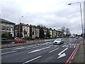
1
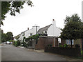
East end of Langton Way
Langton Way is a private road with very eclectic architecture in the individually built houses along its length.
Image: © Stephen Craven
Taken: 31 Aug 2014
0.03 miles
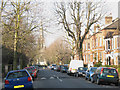
2
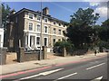
Shooters Hill
Housing at Shooters Hill.
Image: © Alan Hughes
Taken: 14 Jul 2018
0.04 miles
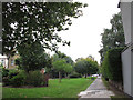
3
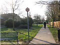
Vicarage Avenue
As the map shows, this strip of greenery, with a footpath, between suburban streets follows the route of a railway tunnel below. Presumably it was not possible to build houses over the tunnel.
Image: © Stephen Craven
Taken: 16 Feb 2008
0.06 miles
4
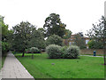
Vicarage Avenue, looking north
The Avenue is a long, broad green space that marks the route of the Blackheath to Charlton railway tunnel beneath. There are public footpaths along each side.
Image: © Stephen Craven
Taken: 31 Aug 2014
0.06 miles
6
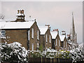
Roofs of houses on St John's Park
The photo is taken from the car park on Old Dover Road and shows the pitched roofs of several houses on the north side of St John's Park. The spire in the distance is St John's church from which the road is named.
The photo was taken just after 5cm of snow had fallen.
Image: © Stephen Craven
Taken: 18 Dec 2010
0.08 miles
7
Vicarage Avenue, looking south
The Avenue is a long, broad green space that marks the route of the Blackheath to Charlton railway tunnel beneath. There are public footpaths along each side.
Image: © Stephen Craven
Taken: 31 Aug 2014
0.09 miles
8
St John's Park, Blackheath
The 'Park' is just the name of this road which runs roughly east/west either way from Image
Image: © Stephen Craven
Taken: 16 Feb 2008
0.09 miles
9
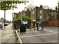
Charging point on Old Dover Road
Since I was last here in 2015, an electric car charging point has appeared at the end of the shoppers' car park .
Image: © Stephen Craven
Taken: 28 Apr 2019
0.10 miles
10
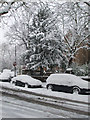
Tree on St John's Park
The day the world stopped still and people went out exploring in the snow
Image: © Linda Craven
Taken: 2 Feb 2009
0.10 miles