IMAGES TAKEN NEAR TO
Old Dover Road, LONDON, SE3 7BT
Introduction
This page details the photographs taken nearby to Old Dover Road, SE3 7BT by members of the Geograph project.
The Geograph project started in 2005 with the aim of publishing, organising and preserving representative images for every square kilometre of Great Britain, Ireland and the Isle of Man.

There are currently over 7.5m images from over14,400 individuals and you can help contribute to the project by visiting https://www.geograph.org.uk
Image Map
Images are licensed for reuse under creativecommons.org/licenses/by-sa/2.0
Notes
- Clicking on the map will re-center to the selected point.
- The higher the marker number, the further away the image location is from the centre of the postcode.
Image Listing (237 Images Found)
Images are licensed for reuse under creativecommons.org/licenses/by-sa/2.0
Image
Details
Distance
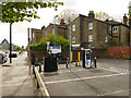
1
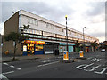
Shops on Old Dover Road
This photo was taken in the early evening, with only the fish and chip shop open. For the other side of the road in rather different conditions, see Image
Image: © Stephen Craven
Taken: 4 Jul 2013
0.00 miles
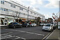
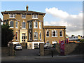
3
Library and shops on Old Dover Road
The nearer half of the block of buildings shown here is the Blackheath Library. The further half is a row of shops, which as of 2010 included a pet shop, health food shop, DIY shop, cafe and one empty unit (formerly a computer repair workshop).
Image: © Stephen Craven
Taken: 18 Dec 2010
0.01 miles
4
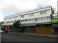
Shops on Old Dover Road
This is the further part of the block shown in Image Since I was last here in 2015, the family-run hardware store has been replaced by "The Voewood" which from its website is a womenswear shop. Most are closed here as it was Sunday morning before opening time.
Image: © Stephen Craven
Taken: 28 Apr 2019
0.02 miles
5
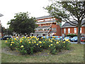
Roses by Schofield Walk
A bed of yellow roses adds colour to this residential block on Old Dover Road.
Image: © Stephen Craven
Taken: 4 Jul 2013
0.03 miles
6
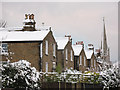
Roofs of houses on St John's Park
The photo is taken from the car park on Old Dover Road and shows the pitched roofs of several houses on the north side of St John's Park. The spire in the distance is St John's church from which the road is named.
The photo was taken just after 5cm of snow had fallen.
Image: © Stephen Craven
Taken: 18 Dec 2010
0.03 miles
7
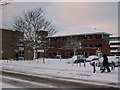
Dornberg Close
The Close is the building in the background: a block of social housing set back from Old Dover Road.
The photo was taken just after 5cm of snow had fallen.
Image: © Stephen Craven
Taken: 18 Dec 2010
0.04 miles
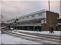
8
Old Dover Road
The flat-roofed building on the right is Blackheath Library. On the opposite side of the road is a parade of shops.
Image: © Stephen Craven
Taken: 16 Dec 2007
0.04 miles
9
Charging point on Old Dover Road
Since I was last here in 2015, an electric car charging point has appeared at the end of the shoppers' car park .
Image: © Stephen Craven
Taken: 28 Apr 2019
0.05 miles
10
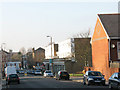
Combe Lodge
This property at 12 Charlton Road is now flats, but I think it was previously a pub or club. During the Olympics its car park was commandeered as "accessible" parking for visitors to Greenwich Park with disabilities - they would be taken by special bus from here to the park.
NB The photographer location is directly over the railway tunnel, whose route passes to the right of the Lodge.
Image: © Stephen Craven
Taken: 8 Aug 2012
0.07 miles