IMAGES TAKEN NEAR TO
Vanbrugh Park, LONDON, SE3 7AG
Introduction
This page details the photographs taken nearby to Vanbrugh Park, SE3 7AG by members of the Geograph project.
The Geograph project started in 2005 with the aim of publishing, organising and preserving representative images for every square kilometre of Great Britain, Ireland and the Isle of Man.

There are currently over 7.5m images from over14,400 individuals and you can help contribute to the project by visiting https://www.geograph.org.uk
Image Map
Images are licensed for reuse under creativecommons.org/licenses/by-sa/2.0
Notes
- Clicking on the map will re-center to the selected point.
- The higher the marker number, the further away the image location is from the centre of the postcode.
Image Listing (154 Images Found)
Images are licensed for reuse under creativecommons.org/licenses/by-sa/2.0
Image
Details
Distance
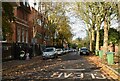
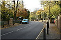
1
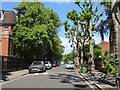
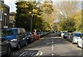
Mycenae Road
Tree lined road - looking north.
Image: © JThomas
Taken: 20 Jun 2022
0.03 miles
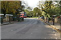
2
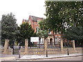
Blackheath High School
On Vanbrugh Park (road).
Has a converted chapel as one of its school buildings.
See http://en.wikipedia.org/wiki/Church_Army_Chapel,_Blackheath for more details.
Image: © David Anstiss
Taken: 11 Sep 2011
0.04 miles
4
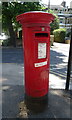
George V postbox on Vanbrugh Park
Postbox No. SE3 47.
Image: © JThomas
Taken: 20 Jun 2022
0.05 miles
10
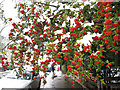
Berries with snow
A magnificent winter display of berries on a bush overhanging Westcombe Park Road.
Technical note: taken with the help of fill-in flash.
Image: © Stephen Craven
Taken: 5 Feb 2012
0.07 miles