IMAGES TAKEN NEAR TO
Wat Tyler Road, LONDON, SE3 0QZ
Introduction
This page details the photographs taken nearby to Wat Tyler Road, SE3 0QZ by members of the Geograph project.
The Geograph project started in 2005 with the aim of publishing, organising and preserving representative images for every square kilometre of Great Britain, Ireland and the Isle of Man.

There are currently over 7.5m images from over14,400 individuals and you can help contribute to the project by visiting https://www.geograph.org.uk
Image Map
Images are licensed for reuse under creativecommons.org/licenses/by-sa/2.0
Notes
- Clicking on the map will re-center to the selected point.
- The higher the marker number, the further away the image location is from the centre of the postcode.
Image Listing (73 Images Found)
Images are licensed for reuse under creativecommons.org/licenses/by-sa/2.0
Image
Details
Distance
1
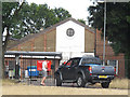
Blackheath drill hall
According to fellow contributor John Maddan, this is "probably the hall shown on the 1896 1:2500 mapping and later surrounded by other buildings, built for the Second West Kent Volunteers and after 1908 used by the Twentieth Battalion London Regiment".
The building is now part of the Blackheath Territorial Army Cadet Centre Image, which is set in an enclosed compound at the western end of the heath, largely surrounded by trees.
I did seek permission through official channels to take photos inside the site but this was declined, so am just submitting one photo taken from a distance.
Image: © Stephen Craven
Taken: 10 Jul 2015
0.03 miles
2
Blackheath Territorial Army Cadet Centre
The training centre is in an enclosed compound at the western end of the heath, largely surrounded by trees.
I did seek permission through official channels to take photos inside the site but this was declined, so am just submitting one photo taken from a distance.
Image: © Stephen Craven
Taken: 10 Jul 2015
0.03 miles
3
Hare and Billet Road, Blackheath Common
This road leads through Blackheath Common towards Blackheath Vale. It later passes the Hare and Billet Public House.
Image: © David Anstiss
Taken: 27 Nov 2009
0.05 miles
4
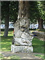
Monument in the grounds of Hollyhedge House
Image: © Siobhan Brennan-Raymond
Taken: 10 Jun 2007
0.06 miles
5
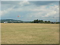
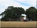
Blackheath (1)
Kite flying is a popular activity here. The tower at the top of Shooters Hill http://www.geograph.org.uk/photo/228327 can just be seen on the horizon to the extreme left of shot while All Saints Church http://www.geograph.org.uk/photo/195272 is to the right.
Image: © Danny P Robinson
Taken: 13 Aug 2006
0.08 miles
6
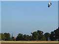
Kite flying on Blackheath
A hot summer evening with a bit of a breeze – ideal conditions for kite flying. The man controlling this one from his skateboard can be seen just in front of the gap with St Margaret’s church spire Image in the distance.
Image: © Stephen Craven
Taken: 19 Jul 2013
0.08 miles
7
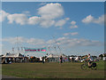
Blackheath Climate Camp - 2
The entrance to a hastily erected but well organised political activists' camp. For more information see Image
Image: © Stephen Craven
Taken: 27 Aug 2009
0.08 miles
8
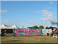
Blackheath Climate Camp - 3
Banners and slogans adorn the fence around a hastily erected but well organised political activists' camp. For more information see Image
Image: © Stephen Craven
Taken: 27 Aug 2009
0.09 miles
9
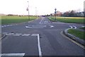
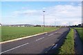
Roundabout on Wat Tyler Road, Blackheath Common
Wat Tyler Road heads right to Lewisham, or left towards the A2 Shooters Hill Road. Hare and Billet Road leads straight on towards Blackheath Vale. Dartmouth Hill heads (behind the viewer) to Dartmouth Row.
Image: © David Anstiss
Taken: 27 Nov 2009
0.10 miles
10
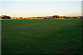
Evening on Blackheath
The sun is already hidden from the foreground, though it still shines on the far side leading up to Shooters Hill.
Image: © Bill Boaden
Taken: 11 Oct 2014
0.10 miles