IMAGES TAKEN NEAR TO
Aberdeen Terrace, LONDON, SE3 0QX
Introduction
This page details the photographs taken nearby to Aberdeen Terrace, SE3 0QX by members of the Geograph project.
The Geograph project started in 2005 with the aim of publishing, organising and preserving representative images for every square kilometre of Great Britain, Ireland and the Isle of Man.

There are currently over 7.5m images from over14,400 individuals and you can help contribute to the project by visiting https://www.geograph.org.uk
Image Map
Images are licensed for reuse under creativecommons.org/licenses/by-sa/2.0
Notes
- Clicking on the map will re-center to the selected point.
- The higher the marker number, the further away the image location is from the centre of the postcode.
Image Listing (41 Images Found)
Images are licensed for reuse under creativecommons.org/licenses/by-sa/2.0
Image
Details
Distance
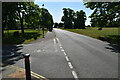
2
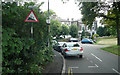
Granville Park - Steep Hill 15%
Granville Park, Blackheath. 15% steep hill down sign.
Image: © Adam Morse
Taken: 8 Aug 2009
0.06 miles

7
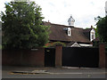
1 The Close, Blackheath
A house with an unusual ventilated turret.
Image: © Stephen Craven
Taken: 10 Jul 2015
0.11 miles
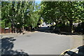
9
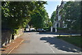
Heath Lane, Blackheath
The top of a road which is a dead end for motor vehicles but a through route across the Kid Brook to Lee for walkers and cyclists.
Image: © Stephen Craven
Taken: 10 Jul 2015
0.12 miles
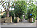
10
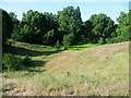
Eliot Pits, Blackheath
Blackheath was once extensively quarried for gravel, sand and chalk, and the pits remained open for many years. During the 1870s, the sharp sides of some of the gravel pits were eased to make them less dangerous. Many of the pits were filled in with bomb rubble after the Second World War, except for one or two around the edge of the Heath. Eliot Pits was possibly left because the land slopes away steeply from the edge of the Heath anyway.
Image: © Marathon
Taken: 31 May 2011
0.13 miles