IMAGES TAKEN NEAR TO
The Orchard, LONDON, SE3 0QU
Introduction
This page details the photographs taken nearby to The Orchard, SE3 0QU by members of the Geograph project.
The Geograph project started in 2005 with the aim of publishing, organising and preserving representative images for every square kilometre of Great Britain, Ireland and the Isle of Man.

There are currently over 7.5m images from over14,400 individuals and you can help contribute to the project by visiting https://www.geograph.org.uk
Image Map
Images are licensed for reuse under creativecommons.org/licenses/by-sa/2.0
Notes
- Clicking on the map will re-center to the selected point.
- The higher the marker number, the further away the image location is from the centre of the postcode.
Image Listing (45 Images Found)
Images are licensed for reuse under creativecommons.org/licenses/by-sa/2.0
Image
Details
Distance

7
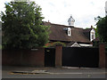
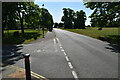
1 The Close, Blackheath
A house with an unusual ventilated turret.
Image: © Stephen Craven
Taken: 10 Jul 2015
0.08 miles
8
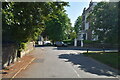
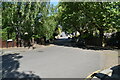
Heath Lane, Blackheath
The top of a road which is a dead end for motor vehicles but a through route across the Kid Brook to Lee for walkers and cyclists.
Image: © Stephen Craven
Taken: 10 Jul 2015
0.09 miles
9
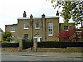
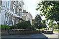
9, Eliot Vale, Blackheath
A notable building, severe in style apart from the front door. Dated 1805.
Image: © Robin Webster
Taken: 30 Oct 2011
0.10 miles
10
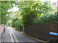
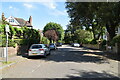
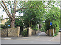
Heath Lane SE3
At the junction of Eliot Vale
Image: © Danny P Robinson
Taken: 13 Aug 2006
0.13 miles