IMAGES TAKEN NEAR TO
Kidbrooke Grove, LONDON, SE3 0PQ
Introduction
This page details the photographs taken nearby to Kidbrooke Grove, SE3 0PQ by members of the Geograph project.
The Geograph project started in 2005 with the aim of publishing, organising and preserving representative images for every square kilometre of Great Britain, Ireland and the Isle of Man.

There are currently over 7.5m images from over14,400 individuals and you can help contribute to the project by visiting https://www.geograph.org.uk
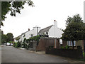
Image Map
Images are licensed for reuse under creativecommons.org/licenses/by-sa/2.0
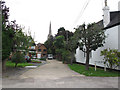
Notes
- Clicking on the map will re-center to the selected point.
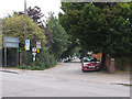
- The higher the marker number, the further away the image location is from the centre of the postcode.
Image Listing (110 Images Found)
Images are licensed for reuse under creativecommons.org/licenses/by-sa/2.0
Image
Details
Distance
1
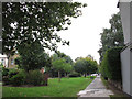
Vicarage Avenue, looking south
The Avenue is a long, broad green space that marks the route of the Blackheath to Charlton railway tunnel beneath. There are public footpaths along each side.
Image: © Stephen Craven
Taken: 31 Aug 2014
0.08 miles
2

80 Langton Way
One of the many idiosyncratic houses along this unadopted road. Photo taken mainly as context for Image
Image: © Stephen Craven
Taken: 27 Jun 2015
0.10 miles
3
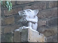
The Blackheath Imp
This little creature, in the tradition of the Lincoln Imp Image, is carved in stone and sits on a brick corbel on the front of a private house Image
Image: © Stephen Craven
Taken: 27 Jun 2015
0.10 miles
4

Excavating a basement
A bungalow on Langton Way had been demolished, and in its place a deep foundation and basement was being constructed ready for the replacement housing.
Image: © Stephen Craven
Taken: 8 Feb 2015
0.11 miles
5

Excavator with roller
I don't think I had previously seen a road roller used as an accessory to an excavator. It was being used for fill around a new basement - see Image
Image: © Stephen Craven
Taken: 8 Feb 2015
0.11 miles
6
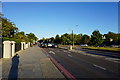
Shooters Hill Road, Blackheath
This is the A2. The sun was getting low and I could not avoid a long shadow of me.
Image: © Bill Boaden
Taken: 11 Oct 2014
0.11 miles
7
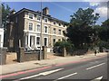
Shooters Hill
Housing at Shooters Hill.
Image: © Alan Hughes
Taken: 14 Jul 2018
0.11 miles
8
Gregor Mews
A small close of houses off Langton Way, with the spire of St John's church beyond.
Image: © Stephen Craven
Taken: 31 Aug 2014
0.12 miles
9
East end of Langton Way
Langton Way is a private road with very eclectic architecture in the individually built houses along its length.
Image: © Stephen Craven
Taken: 31 Aug 2014
0.13 miles
10
Langton Way, looking east
Unlike the western end, the section of Langton Way east of Stratheden Road has been tarmac surfaced at some time, but is now in a bad state. It is closed to motor vehicles except for access, and the official 20mph speed limit is generous: the potholes and ferocious speed humps mean that 10mph is a maximum sensible speed anyway,
Image: © Stephen Craven
Taken: 31 Aug 2014
0.13 miles