IMAGES TAKEN NEAR TO
Rosse Mews, LONDON, SE3 0LA
Introduction
This page details the photographs taken nearby to Rosse Mews, SE3 0LA by members of the Geograph project.
The Geograph project started in 2005 with the aim of publishing, organising and preserving representative images for every square kilometre of Great Britain, Ireland and the Isle of Man.

There are currently over 7.5m images from over14,400 individuals and you can help contribute to the project by visiting https://www.geograph.org.uk
Image Map
Images are licensed for reuse under creativecommons.org/licenses/by-sa/2.0
Notes
- Clicking on the map will re-center to the selected point.
- The higher the marker number, the further away the image location is from the centre of the postcode.
Image Listing (139 Images Found)
Images are licensed for reuse under creativecommons.org/licenses/by-sa/2.0
Image
Details
Distance
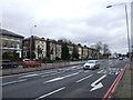
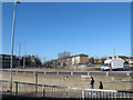
2
Shooters Hill
Housing at Shooters Hill.
Image: © Alan Hughes
Taken: 14 Jul 2018
0.07 miles
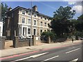
3
East end of Langton Way
Langton Way is a private road with very eclectic architecture in the individually built houses along its length.
Image: © Stephen Craven
Taken: 31 Aug 2014
0.09 miles
4
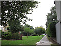
Vicarage Avenue, looking south
The Avenue is a long, broad green space that marks the route of the Blackheath to Charlton railway tunnel beneath. There are public footpaths along each side.
Image: © Stephen Craven
Taken: 31 Aug 2014
0.11 miles
5
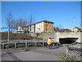
Cycle route through Sun in the Sands junction
This busy road junction was designed with pedestrian /cycle underpasses between the levels of the A2 trunk road below and Shooters Hill Road above. This cyclist sis following the London Cycle Network signs towards Greenwich.
Image: © Stephen Craven
Taken: 27 Feb 2015
0.12 miles
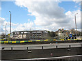
6
London Marathon 2019: elite women
Some of the elite women runners, who set off behind the elite men but with a head start on the mass run.
Image: © Stephen Craven
Taken: 28 Apr 2019
0.12 miles
7
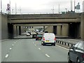
Sun-in-the Sands Junction, A102
The Sun in the Sands interchange was built in the late 1960's for the A2 and the A102(M), it was to be a part of the London Ringway system. The A2 branches to the left, Shooters Hill whilst the road ahead continues, under the roundabout, as the A102 (previously A102M).
Image: © David Dixon
Taken: 15 May 2013
0.12 miles
8
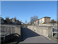
Footbridge within Sun in the Sands junction
This busy road junction was designed with pedestrian /cycle underpasses between the levels of the A2 trunk road below and Shooters Hill Road above. For an earlier view of this footbridge from the other side, see Image, and for the A2 below it, see Image
Image: © Stephen Craven
Taken: 27 Feb 2015
0.12 miles
9
Sun in the Sands roundabout
A busy road junction between the A2 trunk road (in a cutting at this point) and Shooters Hill Road above. The pedestrian is walking down towards the network of subways that link all corners of the junction Image
Image: © Stephen Craven
Taken: 27 Feb 2015
0.12 miles
10
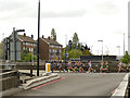
Sun in the Sands roundabout
The roundabout is on the junction of the 'old' A2 (Shooters Hill) and the modern A2 dual carriageway that runs beneath it. There is a pedestrian bridge at the intermediate level, reached from this top level by subways. Here the roundabout is traffic free ready for the London Marathon to pass.
Image: © Stephen Craven
Taken: 13 Apr 2008
0.13 miles