IMAGES TAKEN NEAR TO
Hartslock Drive, LONDON, SE2 9XA
Introduction
This page details the photographs taken nearby to Hartslock Drive, SE2 9XA by members of the Geograph project.
The Geograph project started in 2005 with the aim of publishing, organising and preserving representative images for every square kilometre of Great Britain, Ireland and the Isle of Man.

There are currently over 7.5m images from over14,400 individuals and you can help contribute to the project by visiting https://www.geograph.org.uk
Image Map
Images are licensed for reuse under creativecommons.org/licenses/by-sa/2.0
Notes
- Clicking on the map will re-center to the selected point.
- The higher the marker number, the further away the image location is from the centre of the postcode.
Image Listing (80 Images Found)
Images are licensed for reuse under creativecommons.org/licenses/by-sa/2.0
Image
Details
Distance
1
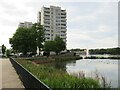
Flats overlooking South Mere, Thamesmead
High rise flats overlooking South Mere in Thamesmead, in south east London.
Image: © Malc McDonald
Taken: 18 Sep 2021
0.03 miles
2
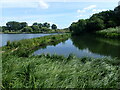
Green Chain Walk on Thamesmead
The Green Chain Walk though Thamesmead is here seen as it approaches the lake at Southmere. One of the ubiquitous Thamesmead tower blocks can be seen on the left. Because of fears over flooding from the Thames as much of this area is below high tide level, the first parts of Thamesmead as here were built with all living accommodation at first floor level or above.
Image: © Marathon
Taken: 8 Mar 2011
0.04 miles
3

Green Chain Walk approach to Southmere
The Green Chain Walk though Thamesmead is here seen as it approaches the lake at Southmere. One of the ubiquitous Thamesmead tower blocks can be seen through the trees on the left. Because of fears over flooding from the Thames as much of this area is below high tide level, the first parts of Thamesmead as here were built with all living accommodation at first floor level or above.
Image: © Marathon
Taken: 8 Mar 2011
0.04 miles
4
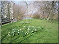
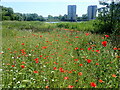
Wild flowers on Thamesmead
This superb show of wild flowers are mostly those which would formerly be found in corn fields. They were seen in the first half of June alongside the Green Chain Walk on Thamesmead between Abbey Road and Southmere. This is just as Southmere is approached. Apart from poppies, cornflowers, corncockles, corn marigolds and ox-eye daisies were prominent.
Image: © Marathon
Taken: 9 Jun 2022
0.04 miles
5
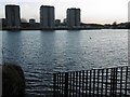
Southmere Lake, Thamesmead
Southmere was the first artificial lake to be created in Thamesmead. This is the view from the Green Chain Walk looking across the lake on a wintry sunset. The tower blocks are part of the original 1970s Thamesmead and are in Hartslock Drive.
Image: © Marathon
Taken: 9 Feb 2016
0.05 miles
6
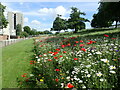
Poppies at South Mere
South Mere was the first artificial lake to be created in Thamesmead. Recently a very impressive wildflower area has been created on the east side of South Mere which extends for some hundred yards alongside the Green Chain Walk. There must be well over one thousand poppies, as well as other wild flowers.
In this photograph some of the Thamesmead tower blocks can be seen beyond the lake.
Image: © Marathon
Taken: 14 Jun 2021
0.05 miles
7
Southmere on Thamesmead
The Green Chain Walk passes here and continues beyond the far side of the lake.
Image: © Marathon
Taken: 9 Jun 2022
0.06 miles
8

sunset
Sunset over Southmere Lake with the flats in shadow
Image: © Linda Craven
Taken: 7 Dec 2008
0.06 miles
9
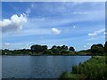
Southmere on Thamesmead
The Green Chain Walk passes here and continues beyond the far side of the lake.
Image: © Marathon
Taken: 9 Jun 2022
0.07 miles
10

Horse warning
The only horse in this view didn't look like running anywhere soon. But see Image for an explanation and Image for an example.
Image: © Stephen Craven
Taken: 9 Jun 2012
0.07 miles