IMAGES TAKEN NEAR TO
Ampleforth Road, LONDON, SE2 9BH
Introduction
This page details the photographs taken nearby to Ampleforth Road, SE2 9BH by members of the Geograph project.
The Geograph project started in 2005 with the aim of publishing, organising and preserving representative images for every square kilometre of Great Britain, Ireland and the Isle of Man.

There are currently over 7.5m images from over14,400 individuals and you can help contribute to the project by visiting https://www.geograph.org.uk
Image Map
Images are licensed for reuse under creativecommons.org/licenses/by-sa/2.0
Notes
- Clicking on the map will re-center to the selected point.
- The higher the marker number, the further away the image location is from the centre of the postcode.
Image Listing (45 Images Found)
Images are licensed for reuse under creativecommons.org/licenses/by-sa/2.0
Image
Details
Distance
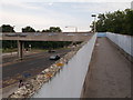
1
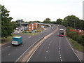
Harrow Manor Way
As seen from Image
This dual carriageway leads towards Thamesmead and the A2016 Eastern Way.
Image: © David Anstiss
Taken: 21 Aug 2011
0.10 miles
2
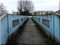
Concrete walkway over Harrow Manor Way, Abbey Wood
Image: © Chris Whippet
Taken: 22 Mar 2015
0.10 miles
3
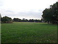
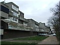
Green between Godstone Road and Ampleforth Road
Recreational Green in Abbey Wood.
Image: © David Anstiss
Taken: 21 Aug 2011
0.11 miles
4
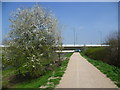
The Ridgeway on Thamesmead
The Ridgeway is a raised footpath from Plumstead station to Crossness which follows the embankment containing the Southern Outfall Sewer on its way to Crossness Sewage Treatment Works. It is seen here adjacent to Sewell Road. Ahead is the flyover taking Harrow Manor Way over Eastern Way.
Image: © Marathon
Taken: 9 Apr 2015
0.11 miles
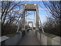
5
Footbridge over Harrow Manor Way
This bridge leads from Binsey Walk, towards a green near Godstone Road.
Image: © David Anstiss
Taken: 21 Aug 2011
0.12 miles
6
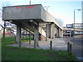
Thamesmead: A2041 Harrow Manorway footbridge
The footbridge links the Abbey Wood Park area to Southmere.
Image: © Nigel Cox
Taken: 31 Jan 2007
0.13 miles
7
Thamesmead Library
Beside Harrow Manor Way, part of the shops on Binsey Walk.
Image: © David Anstiss
Taken: 21 Aug 2011
0.13 miles
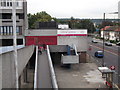
8
Thamesmead: A2016 Eastern Way footbridge
This footbridge links the Southmere area with the main area of Thamesmead.
Image: © Nigel Cox
Taken: 31 Jan 2007
0.13 miles
10
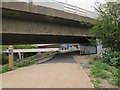
Low headroom on the Ridgeway
The road junction was obviously built at a time when the planners did not envisage the sewer embankment below it becoming a popular traffic-free cycle path. But unless you are very tall it is possible to walk under here without ducking.
Image: © Stephen Craven
Taken: 19 Apr 2015
0.14 miles