IMAGES TAKEN NEAR TO
Waldstock Road, LONDON, SE28 8SF
Introduction
This page details the photographs taken nearby to Waldstock Road, SE28 8SF by members of the Geograph project.
The Geograph project started in 2005 with the aim of publishing, organising and preserving representative images for every square kilometre of Great Britain, Ireland and the Isle of Man.

There are currently over 7.5m images from over14,400 individuals and you can help contribute to the project by visiting https://www.geograph.org.uk
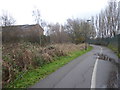
Image Map
Images are licensed for reuse under creativecommons.org/licenses/by-sa/2.0
Notes
- Clicking on the map will re-center to the selected point.
- The higher the marker number, the further away the image location is from the centre of the postcode.
Image Listing (52 Images Found)
Images are licensed for reuse under creativecommons.org/licenses/by-sa/2.0
Image
Details
Distance
1
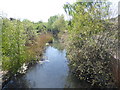
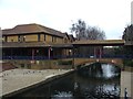
Thamesmead canal
The landscaped canals were former drainage ditches on Plumstead and Erith Marshes. This is just south of the Town Centre where they are a little more natural and hidden largely by trees, even in winter. Just to the north though the canal is more formal when it reaches the Town Centre - see http://www.geograph.org.uk/photo/4292286
Image: © Marathon
Taken: 28 Dec 2014
0.05 miles
2
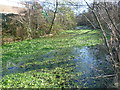
Drainage ditch at Thamesmead
The former drainage ditches on Plumstead and Erith Marshes have been landscaped into the development as seen at https://www.geograph.org.uk/photo/6449924 which is a few yards north of here. This view from Central way shows a more natural form.
Image: © Marathon
Taken: 20 Apr 2020
0.05 miles
3
Path and canal on Thamesmead
The landscaped canals were former drainage ditches on Plumstead and Erith Marshes. This is just south of the Town Centre where they are a little more natural and hidden largely by trees, even in winter. Just to the north though the canal is more formal when it reaches the Town Centre - see http://www.geograph.org.uk/photo/4292286
Image: © Marathon
Taken: 28 Dec 2014
0.05 miles
5

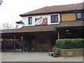
Night time drive-through
Not my cup of tea, but makes for an interesting shot.
Image: © David Martin
Taken: 10 Oct 2014
0.11 miles
6
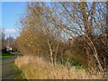
Path alongside drainage ditch, Thamesmead
The landscaped canals were former drainage ditches on Plumstead and Erith Marshes. This drainage ditch, which hasn't been landscaped, is just south of the Town Centre and Central Way and is hidden largely by trees and reeds, even in winter. Just to the north, though, the canal is more formal when it reaches the Town Centre - see http://www.geograph.org.uk/photo/4292286
Image: © Marathon
Taken: 31 Dec 2017
0.12 miles
7
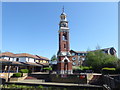
Thamesmead Town Centre Clock
The Thamesmead Town Centre Clock is here seen across one of the landscaped canals which were former drainage ditches on Plumstead and Erith Marshes.
The 18th century clock faces and cupola were donated to the Greater London Council who built Thamesmead. They came from the former Great Storehouse of the Deptford Royal Dockyard, which was demolished in 1981. The GLC paid for them to be restored and later funded the construction of a supporting 100 feet high clock tower in the classical style, which was completed in 1987.
Image: © Marathon
Taken: 20 Apr 2020
0.12 miles
10
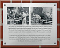
History on the Clock Tower
On a wall of the clock tower in the centre of Thamesmead is a small photo panel with a short history of the area's military past.
Image: © Des Blenkinsopp
Taken: 17 Oct 2023
0.13 miles