IMAGES TAKEN NEAR TO
Silver Birch Close, LONDON, SE28 8RW
Introduction
This page details the photographs taken nearby to Silver Birch Close, SE28 8RW by members of the Geograph project.
The Geograph project started in 2005 with the aim of publishing, organising and preserving representative images for every square kilometre of Great Britain, Ireland and the Isle of Man.

There are currently over 7.5m images from over14,400 individuals and you can help contribute to the project by visiting https://www.geograph.org.uk
Image Map
Images are licensed for reuse under creativecommons.org/licenses/by-sa/2.0
Notes
- Clicking on the map will re-center to the selected point.
- The higher the marker number, the further away the image location is from the centre of the postcode.
Image Listing (10 Images Found)
Images are licensed for reuse under creativecommons.org/licenses/by-sa/2.0
Image
Details
Distance
1

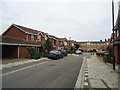
Floathaven Close, Thamesmead, London SE28
Image: © Stacey Harris
Taken: 5 Jun 2011
0.04 miles
2
Floathaven Close, Thamesmead, London SE28
Image: © Stacey Harris
Taken: 5 Jun 2011
0.06 miles
3
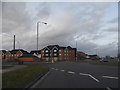
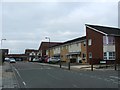
Roundabout on Central Way, Thamesmead
This looks far more like a new town in adjacent Kent or Essex than anywhere in London.
Image: © David Howard
Taken: 23 Feb 2014
0.11 miles
6
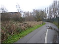
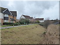
Path alongside drainage ditch, Thamesmead
The landscaped canals were former drainage ditches on Plumstead and Erith Marshes. This drainage ditch, which hasn't been landscaped, is just south of the Town Centre and Central Way and is hidden largely by trees and reeds, even in winter. Just to the north, though, the canal is more formal when it reaches the Town Centre - see http://www.geograph.org.uk/photo/4292286
Image: © Marathon
Taken: 31 Dec 2017
0.19 miles
7
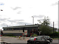
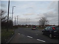
Royal Mail distribution centre
This centre is a relatively new building on an industrial estate in Thamesmead.
A number 472 bus can be seen at left.
Image: © Stephen Craven
Taken: 9 Jun 2012
0.21 miles
8
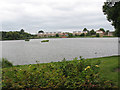
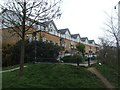
Birchmere
One of several small lakes in Thamesmead new town, which form part of the complex land drainage arrangements in this former marshland.
Image: © Stephen Craven
Taken: 25 Aug 2008
0.22 miles
10
Drainage ditch alongside Waterside Close on Thamesmead
The landscaped canals were former drainage ditches on Plumstead and Erith Marshes. This small drainage ditch is just west of the Town Centre, alongside Waterside Close, and leads into Twin Tumps.
Image: © Marathon
Taken: 31 Dec 2017
0.25 miles