IMAGES TAKEN NEAR TO
Thamesbank Place, LONDON, SE28 8PR
Introduction
This page details the photographs taken nearby to Thamesbank Place, SE28 8PR by members of the Geograph project.
The Geograph project started in 2005 with the aim of publishing, organising and preserving representative images for every square kilometre of Great Britain, Ireland and the Isle of Man.

There are currently over 7.5m images from over14,400 individuals and you can help contribute to the project by visiting https://www.geograph.org.uk
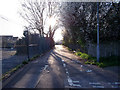
Image Map
Images are licensed for reuse under creativecommons.org/licenses/by-sa/2.0
Notes
- Clicking on the map will re-center to the selected point.
- The higher the marker number, the further away the image location is from the centre of the postcode.
Image Listing (41 Images Found)
Images are licensed for reuse under creativecommons.org/licenses/by-sa/2.0
Image
Details
Distance
1
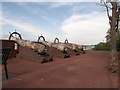
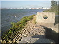
Cannons beside the River Thames
These four cannons are on a small esplanade and open space area, part of the Crossways housing estate.
Image: © David Anstiss
Taken: 21 Aug 2011
0.02 miles
3
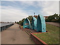
Three boats beside the River Thames
These halves of boats (turned into seating) are beside the Thames Path (long distance path) leading past Crossway housing estate towards Erith.
Image: © David Anstiss
Taken: 21 Aug 2011
0.04 miles
4
Thamesmead Riverside
This is the point at which the Thames Path changes from the softer, more natural surface which has come from Cross Ness to the more heavily engineered river wall which runs almost to Tripcock Ness.
Image: © Marathon
Taken: 26 Jun 2010
0.05 miles
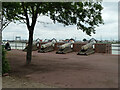
5
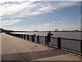
Fishing on the Thames Path
This esplanade beside the River Thames, is on the Thames Path (long distance path) leading from Erith past Crossway housing estate towards Thamesmead.
Across the river, the Image can just be seen.
Image: © David Anstiss
Taken: 21 Aug 2011
0.05 miles
6
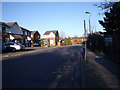
Copperfield Road
Looking east, with the fence of Castilion Primary School on the right and Voyagers Close off to the left.
Image: © Linda Craven
Taken: 9 Mar 2014
0.06 miles
7
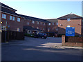
Marlborough Court
A residential care home for older people on Copperfield Road, Thamesmead
Image: © Linda Craven
Taken: 9 Mar 2014
0.08 miles
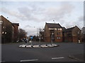
9
Footpath towards Manorway Green
This urban footpath leads from the western end of Copperfield Road to link to the north-south path along the Bexley/Greenwich border known as Manorway Green. To the left is the car park of Castilion Primary School.
Image: © Linda Craven
Taken: 9 Mar 2014
0.09 miles
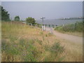
10
Thames embankment at Thamesmead
This marks the end of the engineered river wall to the west and the start of the more natural embankment past Cross Ness to the east. Dagenham can be seen across the river.
Image: © Marathon
Taken: 30 Aug 2010
0.10 miles