IMAGES TAKEN NEAR TO
Poplar Place, LONDON, SE28 8GS
Introduction
This page details the photographs taken nearby to Poplar Place, SE28 8GS by members of the Geograph project.
The Geograph project started in 2005 with the aim of publishing, organising and preserving representative images for every square kilometre of Great Britain, Ireland and the Isle of Man.

There are currently over 7.5m images from over14,400 individuals and you can help contribute to the project by visiting https://www.geograph.org.uk
Image Map
Images are licensed for reuse under creativecommons.org/licenses/by-sa/2.0
Notes
- Clicking on the map will re-center to the selected point.
- The higher the marker number, the further away the image location is from the centre of the postcode.
Image Listing (36 Images Found)
Images are licensed for reuse under creativecommons.org/licenses/by-sa/2.0
Image
Details
Distance
1
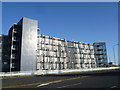
This is not Belmarsh Prison
Belmarsh is about a mile away but it could easily be imagined that the same architect was responsible for both. This metallic creation, seen here across Carlyle Road in Thamesmead, has metal bars everywhere which are very reminiscent of a prison. Worse still, there is not a hint of greenery anywhere to break up the stark lines of these flats.
Image: © Marathon
Taken: 27 Oct 2014
0.01 miles
2
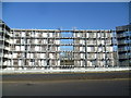
Metallic living on Thamesmead
Belmarsh is about a mile away but it could easily be imagined that the same architect was responsible for both the prison and these flats. This metallic creation, seen here across Carlyle Road in Thamesmead, has metal bars everywhere which are very reminiscent of a prison. Worse still, there is not a hint of greenery anywhere to break up the stark lines of these flats.
Image: © Marathon
Taken: 27 Oct 2014
0.02 miles
3
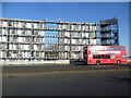
At least the bus provides some colour
Belmarsh is about a mile away but it could easily be imagined that the same architect was responsible for both the prison and these flats. This metallic creation, seen here across Carlyle Road in Thamesmead, has metal bars everywhere which are very reminiscent of a prison. Worse still, there is not a hint of greenery anywhere to break up the stark lines of these flats.
Image: © Marathon
Taken: 27 Oct 2014
0.03 miles
4
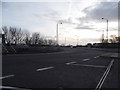
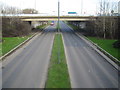
Roundabout on Carlyle Road, Thamesmead
At the junction of Eastern Way
Image: © David Howard
Taken: 23 Feb 2014
0.07 miles
5
Thamesmead: A2016 Eastern Way
This is the view from the footbridge in Image, looking towards the eastern overbridge carrying the A2041 over the dual carriageway.
Image: © Nigel Cox
Taken: 31 Jan 2007
0.07 miles
6
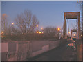
Thamesmead footbridge at dusk
A view of Image at dusk. The pedestrian route weaves its way under and over the traffic lanes of a complex junction, sometimes with little headroom. Coming down its northern end into the backstreets of a 1970's housing estate, it is a typical concrete cityscape, unwelcoming at the best of times, and not really the place you want to be after dark. This was the last photo I took that day before catching a bus home.
Image: © Stephen Craven
Taken: 7 Dec 2008
0.08 miles
7
Bexley side of the Ridgeway
Compare this with the Greenwich section Image
Image: © Stephen Craven
Taken: 19 Apr 2015
0.12 miles
8
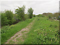
Borough boundary on the Ridgeway
Greenwich borough had upgraded its section of the Ridgeway path (foreground) in 2015. The section beyond here Image is in Bexley borough and had not been upgraded yet.
Image: © Stephen Craven
Taken: 19 Apr 2015
0.12 miles
9
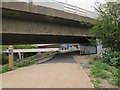
Low headroom on the Ridgeway
The road junction was obviously built at a time when the planners did not envisage the sewer embankment below it becoming a popular traffic-free cycle path. But unless you are very tall it is possible to walk under here without ducking.
Image: © Stephen Craven
Taken: 19 Apr 2015
0.13 miles
10
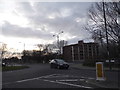
Roundabout on Crossway, Thamesmead
Crossway is a crescent providing access to the housing in East Thamesmead.
Image: © David Howard
Taken: 23 Feb 2014
0.13 miles