IMAGES TAKEN NEAR TO
Hill View Drive, LONDON, SE28 0LL
Introduction
This page details the photographs taken nearby to Hill View Drive, SE28 0LL by members of the Geograph project.
The Geograph project started in 2005 with the aim of publishing, organising and preserving representative images for every square kilometre of Great Britain, Ireland and the Isle of Man.

There are currently over 7.5m images from over14,400 individuals and you can help contribute to the project by visiting https://www.geograph.org.uk
Image Map
Images are licensed for reuse under creativecommons.org/licenses/by-sa/2.0
Notes
- Clicking on the map will re-center to the selected point.
- The higher the marker number, the further away the image location is from the centre of the postcode.
Image Listing (52 Images Found)
Images are licensed for reuse under creativecommons.org/licenses/by-sa/2.0
Image
Details
Distance
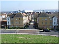
1
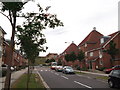
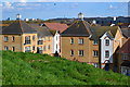
Hill View Drive, Thamesmead East
Part of the Gallions Reach Urban Village (eco-park), heading towards Gallions Hill (in the background). Some of the roofs of the estate have been 'inspired' by Oast Houses.
Image: © David Anstiss
Taken: 21 Aug 2011
0.00 miles
2
Hill View Drive seen from Gallions Hill
Gallions Hill is a sixty feet high landmark created from "recycled excavated material". A spiral path leads to the summit which provides widespread views up and down the Thames. To the south the views are only as far as the ridge between Shooters Hill, Plumstead Common, Bostall Heath and Lesnes Abbey Woods.
Image: © Marathon
Taken: 20 Mar 2015
0.01 miles
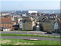
3
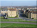
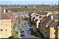
View from the summit of Gallions Hill
Gallions Hill is a sixty feet high landmark created from "recycled excavated material". A spiral path leads to the summit which provides widespread views up and down the Thames. To the south the views are only as far as the ridge between Shooters Hill, Plumstead Common, Bostall Heath and Lesnes Abbey Woods.
This view from the summit looks down Hill View Drive. The Belvedere Refuse Incinerator can be seen on the horizon, left of centre - see http://www.geograph.org.uk/photo/2356994
Image: © Marathon
Taken: 20 Mar 2015
0.01 miles
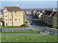
4
Hill View Drive, Thamesmead
Houses east of the Thamesmead Tor (alias Gallions Hill) from which the view was taken and from which the street gets its name.
Image: © Stephen Craven
Taken: 21 Apr 2014
0.01 miles
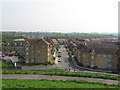
6
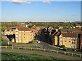
Gallions Reach Urban Village
A view of Gallions Reach Urban Village, developed in the early 200s, taken from the top of Gallions Hill in Thamesmead.
This image was taken in the late afternoon on an October day, as shadows were lengthening.
Image: © Malc McDonald
Taken: 8 Oct 2022
0.05 miles
7
View over housing from the edge of Gallions Hill
Image: © David Martin
Taken: 12 Apr 2016
0.05 miles
8
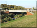
Canal bridge, Thamesmead
A bridge carrying a road over a canal in Thamesmead, South East London.
Image: © Malc McDonald
Taken: 22 Oct 2011
0.07 miles
9
View from Gallions Hill
Gallions Hill is a sixty feet high landmark created from "recycled excavated material". A spiral path leads to the summit which provides widespread views up and down the Thames. To the south the views are only as far as the ridge between Shooters Hill, Plumstead Common, Bostall Heath and Lesnes Abbey Woods. The large white building in the distance is known as 'Iron Mountain' - see http://www.geograph.org.uk/photo/2990467
Image: © Marathon
Taken: 20 Mar 2015
0.07 miles
10
View from the summit of Gallions Hill
Gallions Hill is a sixty feet high landmark created from "recycled excavated material". A spiral path leads to the summit which provides widespread views up and down the Thames. To the south the views are only as far as the ridge between Shooters Hill, Plumstead Common, Bostall Heath and Lesnes Abbey Woods. The large white building in the distance is known as 'Iron Mountain' - see http://www.geograph.org.uk/photo/2990467
Image: © Marathon
Taken: 20 Mar 2015
0.07 miles