IMAGES TAKEN NEAR TO
Kentlea Road, LONDON, SE28 0JX
Introduction
This page details the photographs taken nearby to Kentlea Road, SE28 0JX by members of the Geograph project.
The Geograph project started in 2005 with the aim of publishing, organising and preserving representative images for every square kilometre of Great Britain, Ireland and the Isle of Man.

There are currently over 7.5m images from over14,400 individuals and you can help contribute to the project by visiting https://www.geograph.org.uk
Image Map
Images are licensed for reuse under creativecommons.org/licenses/by-sa/2.0
Notes
- Clicking on the map will re-center to the selected point.
- The higher the marker number, the further away the image location is from the centre of the postcode.
Image Listing (61 Images Found)
Images are licensed for reuse under creativecommons.org/licenses/by-sa/2.0
Image
Details
Distance
1
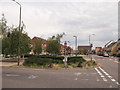
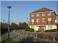
Small garden/open space on Battery Road
Battery Road is the main road through the Gallions Park Eco estate.
It leads around this rectangular garden area.
Image: © David Anstiss
Taken: 21 Aug 2011
0.05 miles
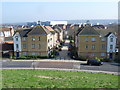
2
New Acres Road, West Thamesmead
As seen from Battery Road.
In the background is Gallions Hill.
Image: © David Anstiss
Taken: 21 Aug 2011
0.07 miles
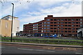
3
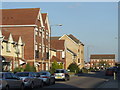
Battery Road, Thamesmead
New housing in Thamesmead, South East London.
Thamesmead is a new town, established in the late 1960s on reclaimed marshland. The town continues to grow, and is home to up to 50,000 people.
Image: © Malc McDonald
Taken: 22 Oct 2011
0.10 miles
4
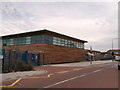
Discovery Primary School, Thamesmead
On Battery Road, within Thamesmead Ecopark.
Image: © David Anstiss
Taken: 21 Aug 2011
0.12 miles
5
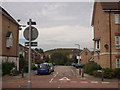
Cycle path, Thamesmead
A cycle path in Thamesmead, South East London.
Thamesmead is a new town which has been developed since the late 1960s, on reclaimed marshland.
Image: © Malc McDonald
Taken: 22 Oct 2011
0.13 miles
7
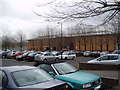
Her Majesty's Prison, Belmarsh
Photographed from the visitor's car park. It was as far as I wanted to go...
Image: © Dr Neil Clifton
Taken: 27 Mar 2006
0.14 miles
8
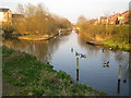
Thamesmead: Gallions Canal
Large parts of Thamesmead are on land originally contaminated by the activities of the former Woolwich Royal Arsenal. The land was first recovered by the GLC for residential use in the 1960s. As part of this redevelopment a system of canals and lakes were built in order to store and manage surface water run-off prior to its discharge into the River Thames. As part of the current development Tilfen Land Limited have retained and rebuilt sections of the old system, again to manage surface water run-off, including the provision of flood storage areas, but also to provide an ecology corridor and a public amenity through the residential areas. There is a .pdf file describing the scheme on Tilfen's website here http://www.tilfenland.co.uk/pdf/reshapingenvironments.pdf
This image was taken from the east side of Delisle Road with New Acres Road on the right. It is difficult to categorize the photo on the Geograph site in the sense that it is not an old navigable canal, nor a river, but an artificial drainage cut. "Drain" in the sense of a fenland drain therefore seems most suitable.
Image: © Nigel Cox
Taken: 26 Mar 2007
0.14 miles
9
View from Gallions Hill
Gallions Hill is a sixty feet high landmark created from "recycled excavated material". A spiral path leads to the summit which provides widespread views up and down the Thames. To the south the views are only as far as the ridge between Shooters Hill, Plumstead Common, Bostall Heath and Lesnes Abbey Woods. The large white building in the distance is known as 'Iron Mountain' - see http://www.geograph.org.uk/photo/2990467
Image: © Marathon
Taken: 20 Mar 2015
0.14 miles
10
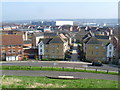
View from the summit of Gallions Hill
Gallions Hill is a sixty feet high landmark created from "recycled excavated material". A spiral path leads to the summit which provides widespread views up and down the Thames. To the south the views are only as far as the ridge between Shooters Hill, Plumstead Common, Bostall Heath and Lesnes Abbey Woods. The large white building in the distance is known as 'Iron Mountain' - see http://www.geograph.org.uk/photo/2990467
Image: © Marathon
Taken: 20 Mar 2015
0.15 miles