IMAGES TAKEN NEAR TO
Ware Point Drive, LONDON, SE28 0HF
Introduction
This page details the photographs taken nearby to Ware Point Drive, SE28 0HF by members of the Geograph project.
The Geograph project started in 2005 with the aim of publishing, organising and preserving representative images for every square kilometre of Great Britain, Ireland and the Isle of Man.

There are currently over 7.5m images from over14,400 individuals and you can help contribute to the project by visiting https://www.geograph.org.uk
Image Map
Images are licensed for reuse under creativecommons.org/licenses/by-sa/2.0
Notes
- Clicking on the map will re-center to the selected point.
- The higher the marker number, the further away the image location is from the centre of the postcode.
Image Listing (88 Images Found)
Images are licensed for reuse under creativecommons.org/licenses/by-sa/2.0
Image
Details
Distance
1
Flats, Woolwich
Built on the redeveloped Woolwich Arsenal site.
Image: © Robin Webster
Taken: 5 Mar 2011
0.03 miles
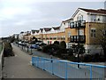
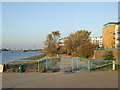
3
Ware Point Drive, Thamesmead, London SE28
Image: © Stacey Harris
Taken: 5 Jun 2011
0.05 miles
4
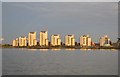
Sunlit Flats
Several high flats at Woolwich on the southern side of the Thames.
Image: © Ashley Dace
Taken: 30 Sep 2010
0.06 miles

6
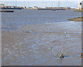
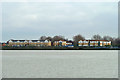
Low tide at Thamesmead
Mud flats at low tide on the Thames. The Barking Barrier Image is visible in the distance.
Image: © Stephen Craven
Taken: 18 Mar 2007
0.07 miles
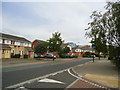
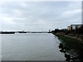
7
Thames Path at Thamesmead
A gate on the Thames Path at Thamesmead, South East London. This section of the path is shared by pedestrians and cyclists, and forms part of National Cycle Network route 1 (NCN1). NCN1 links Dover with Shetland, running up the eastern side of England and Scotland.
Image: © Malc McDonald
Taken: 22 Oct 2011
0.07 miles
8
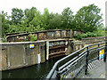
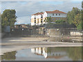
Lock gate and swing bridge, Royal Arsenal Canal
The inner end of the entrance lock from the Thames, now non-functional. Lock and swing bridge are grade II listed structures. I thought the bridge was for the arsenal's narrow gauge railway, a very extensive 18 inch (457 mm) gauge system. However, the listing citation refers to a standard gauge link crossing here. It may have been both - dual gauge tracks existed elsewhere on the site.
Image: © Robin Webster
Taken: 25 Jun 2011
0.08 miles
10
The Pilkington Canal, drained (2)
This is the northern end of the short artificial channel, including the disused lock that once allowed access into it from the Thames, drained for a few weeks for maintenance. See also Image
The lock, and the swing bridge visible in the photo, are listed grade 2 (list entry number 1213695). The lock dates from 1812-14 to connect the Royal Arsenal Canal to the Thames, and the bridge came later, c.1876 to serve a standard gauge railway line to connect to the London Chatham and Dover Railway at Plumstead. The bridge is on the 2014 "Heritage at Risk" register.
Image: © Stephen Craven
Taken: 4 Oct 2009
0.08 miles