IMAGES TAKEN NEAR TO
Benton's Lane, LONDON, SE27 9UD
Introduction
This page details the photographs taken nearby to Benton's Lane, SE27 9UD by members of the Geograph project.
The Geograph project started in 2005 with the aim of publishing, organising and preserving representative images for every square kilometre of Great Britain, Ireland and the Isle of Man.

There are currently over 7.5m images from over14,400 individuals and you can help contribute to the project by visiting https://www.geograph.org.uk
Image Map
Images are licensed for reuse under creativecommons.org/licenses/by-sa/2.0
Notes
- Clicking on the map will re-center to the selected point.
- The higher the marker number, the further away the image location is from the centre of the postcode.
Image Listing (63 Images Found)
Images are licensed for reuse under creativecommons.org/licenses/by-sa/2.0
Image
Details
Distance
1
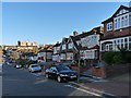
Eylewood Road, West Norwood
These houses were built in the late 1930s.
The dip in the road is the location of the River Effra which is one of London's subterranean rivers.
See also Image
Image: © Robin Drayton
Taken: 10 Nov 2010
0.03 miles
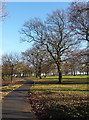
2

Norwood Park, SE27
Looking northwest from Salters Hill
Image: © Philip Talmage
Taken: 8 Sep 2005
0.05 miles
3
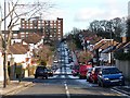
Norwood Park Road
Looking east from Elder Road. A light dusting of overnight snow can still be seen.
Image: © Stephen Richards
Taken: Unknown
0.09 miles
4
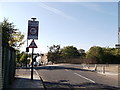
Gipsy Road Road bridge
This road leads from Gipsy Hill towards West Norwood.
It passes over the railway between West Norwood and Gipsy Hill.
Image: © David Anstiss
Taken: 2 Oct 2011
0.09 miles
5
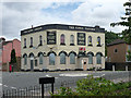
Former Gipsy Tavern, Gipsy Road
The food lies rotting, the sports go unwatched and the garden is a wilderness. This particular pub may not have been much of a loss (I don't know, I never visited it), but there is something melancholic about every entry in the increasingly long catalogue of extinct pubs. I think this one went some time in 2011.
Image: © Stephen Richards
Taken: 9 Jun 2012
0.10 miles
6
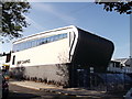
Park Campus, West Norwood School
Specialist sports school on Gipsy Road.
Image: © David Anstiss
Taken: 2 Oct 2011
0.10 miles
7
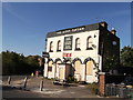
The Gipsy Tavern, West Norwood
Closed public house on the junction of Gipsy Road (in front) and Auckland Hill (on the left).
Image: © David Anstiss
Taken: 2 Oct 2011
0.11 miles
8
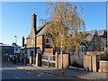
School Buildings, Gipsy Road, West Norwood
In the 1950s this was Gipsy Road infants school.
Subsequently until 2002 it was Norwood Park primary school.
Image: © Robin Drayton
Taken: 10 Nov 2010
0.11 miles
9
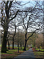
Norwood Park (15)
Large oaks on the left of the path which descends south-west towards the all-weather football pitches and, just beyond, Elder Road. A council sign has the following details:
"The name of the park is a reminder that this high ground was once completely cloaked with trees and was part of the ‘Great North Wood’ which covered over 1,400 acres of the old county of Surrey. Over time the North Wood was gradually lost to housing, fields and roads, and by the end of the C18th it had gone completely in Lambeth. Norwood Park was officially opened to the public in 1911, and contains a splendid mix of trees, a wildlife area, playground, games court and padding pool.”
Image: © Stephen Richards
Taken: 16 Dec 2012
0.11 miles
10
Norwood Park (16)
Large oaks on the right of the path which ascends north-east from Elder Road, a reverse of this view: Image A council sign has the following details:
"The name of the park is a reminder that this high ground was once completely cloaked with trees and was part of the ‘Great North Wood’ which covered over 1,400 acres of the old county of Surrey. Over time the North Wood was gradually lost to housing, fields and roads, and by the end of the C18th it had gone completely in Lambeth. Norwood Park was officially opened to the public in 1911, and contains a splendid mix of trees, a wildlife area, playground, games court and padding pool.”
Image: © Stephen Richards
Taken: 16 Dec 2012
0.12 miles