IMAGES TAKEN NEAR TO
Auckland Hill, LONDON, SE27 9PD
Introduction
This page details the photographs taken nearby to Auckland Hill, SE27 9PD by members of the Geograph project.
The Geograph project started in 2005 with the aim of publishing, organising and preserving representative images for every square kilometre of Great Britain, Ireland and the Isle of Man.

There are currently over 7.5m images from over14,400 individuals and you can help contribute to the project by visiting https://www.geograph.org.uk
Image Map (Loading...)


Getting Data...Please wait
Leaflet Map data © OpenStreetMap
Images are licensed for reuse under creativecommons.org/licenses/by-sa/2.0
Notes
- Clicking on the map will re-center to the selected point.
- The higher the marker number, the further away the image location is from the centre of the postcode.
Image Listing (331 Images Found)
Images are licensed for reuse under creativecommons.org/licenses/by-sa/2.0
Image
Details
Distance
1
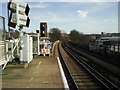
View down the line from West Norwood station
This view standing at the end of the down platform, beyond the bridge over Norwood High Street, looks away from London towards Gipsy Hill. The Crystal Palace TV Mast can just be seen to the right of the signals. The cameras on the left are for the benefit of the train driver, whilst the various signs make it quite clear it is not a good idea for passengers to go any further.
Image: © Marathon
Taken: 24 Feb 2011
0.02 miles
2
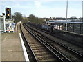
Looking east from West Norwood station
This view standing at the end of the down platform beyond the bridge over Norwood High Street looks away from London towards Gipsy Hill. The Crystal Palace TV Mast can just be seen to the right of the signals, whilst the Upper Norwood Mast is on the extreme right of the photograph.
Image: © Marathon
Taken: 24 Feb 2011
0.03 miles
3
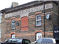
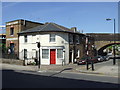
Ghost sign, Pilgrim Hill
Now converted into two houses, this building clearly once served:
"H. DAY & SONS DEPOSITORIES"
The brickwork adds a little interest, a pity about the ugly blocked window.
Image: © Stephen Richards
Taken: 5 Jan 2011
0.05 miles
4
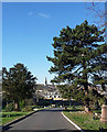
Path, West Norwood Cemetery (4)
West Norwood Cemetery is one of the “Magnificent Seven” cemeteries founded in the early C19th to deal with the expanding population of London. It was laid out by Sir William Tite and opened in 1837. It has 65 Grade II and Grade II* listed monuments.
The conifer on the right is, judging by the bunched needles and cones, a pine of some description.
The prominent spire is that of St Luke: Image
Image: © Stephen Richards
Taken: 2 Feb 2012
0.05 miles
5
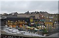
Boat House and Depositories
The Boat House and H Day & Sons building, Norwood High Street.
Image: © Malc McDonald
Taken: 22 May 2010
0.05 miles
6
Travis Perkins lumberyard, off Northwood High St
Image: © N Chadwick
Taken: 8 May 2010
0.05 miles
7
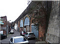
East Place
Short cul-de-sac with light industry and workshops under the railway arches. It is festooned with CCTV cameras and signs warning that the area is monitored.
The road at the end is Pilgrim Hill.
Image: © Stephen Richards
Taken: 5 Jan 2011
0.05 miles
8
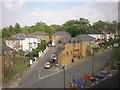
Auckland Hill from the train
Taken from a train just leaving West Norwood station, heading for Gipsy Hill. Auckland Hill rises towards the right of the photo; beyond the cul-de-sac in the centre of the picture the trees mark West Norwood Cemetery.
Image: © Christopher Hilton
Taken: 21 Apr 2011
0.05 miles
9
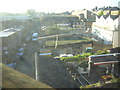
Industrial area near West Norwood Station, from the train
This area of builders' supply yards, light industry and mechanics' shops lies in a dip just to the east of (and parallel to) Norwood High Street, running south from the railway. The dip probably represents the old course of the Effra, one of London's lost rivers.
In the foreground, the beer garden of a pub on Norwood High Street
Image: © Christopher Hilton
Taken: 15 Oct 2011
0.06 miles
