IMAGES TAKEN NEAR TO
Windsor Close, Windsor Grove, LONDON, SE27 9LU
Introduction
This page details the photographs taken nearby to Windsor Close, Windsor Grove, SE27 9LU by members of the Geograph project.
The Geograph project started in 2005 with the aim of publishing, organising and preserving representative images for every square kilometre of Great Britain, Ireland and the Isle of Man.

There are currently over 7.5m images from over14,400 individuals and you can help contribute to the project by visiting https://www.geograph.org.uk
Image Map
Images are licensed for reuse under creativecommons.org/licenses/by-sa/2.0
Notes
- Clicking on the map will re-center to the selected point.
- The higher the marker number, the further away the image location is from the centre of the postcode.
Image Listing (144 Images Found)
Images are licensed for reuse under creativecommons.org/licenses/by-sa/2.0
Image
Details
Distance
1
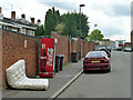
Large items of rubbish, SE27
In Windsor Grove. Mattresses are not uncommon, but Coca-Cola dispensers?
Image: © Robin Webster
Taken: 23 Jul 2011
0.02 miles
2
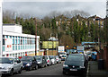
Breaker's yard, Windsor Grove
Sitting pretty atop West Norwood Car Breakers is an old mini (?)
On the left is a Royal Mail Delivery Office which looks very 1960s.
A train runs behind the trees towards West Norwood and beyond that are houses on Auckland Hill.
Image: © Stephen Richards
Taken: 6 Feb 2013
0.04 miles
3
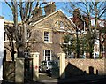
3 and 5 Gipsy Road
A pair of stock brick houses dating from the late C18th or early C19th, making them some of the earliest surviving buildings in the area. They share a lunette in the pediment, and the left-hand house has an extra bay. Grade II listed.
The development of West Norwood began with the breaking up of Lord Thurlow's estate after his death in 1806. Much of this initial phase has since been swept away by subsequent development which accelerated over the second half of the C19th and during the C20th, but there are pockets of houses surviving from the early days, mostly around Knight’s Hill, Norwood High Street/Elder Road and the area between them.
Image: © Stephen Richards
Taken: 30 Jan 2010
0.04 miles
4
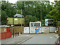
West Norwood Car Breakers
The backdrop of trees are along the railway line east of West Norwood station. One of the rarer varieties of Mini - either a Riley Elf or a Wolseley Hornet - adorns the container on the left.
Image: © Robin Webster
Taken: 23 Jul 2011
0.04 miles
5
Elder Road
A view south along Elder Road. Just visible over the rooftops is the TV transmitter mast at Beulah Heights.
Image: © Malc McDonald
Taken: 22 May 2010
0.06 miles
6
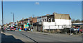
Norwood High Street (1)
A tatty stretch on the east side running north from Windsor Grove (far right). The modest mid-Victorian two-storey houses would probably scrub up reasonably well, but sit far back behind a ragbag of projecting shops, several of which are currently empty. The corner site is empty, save for two rusting Volkswagens.
Image: © Stephen Richards
Taken: 2 Feb 2012
0.07 miles
7
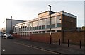
West Norwood Royal Mail Delivery Office, Windsor Grove
Built in 1962.
Image: © Jim Osley
Taken: 31 Oct 2015
0.08 miles
8
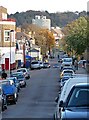
View down Chapel Road
Looking east along Chapel Road and its continuation beyond the traffic lights, Gipsy Road, from near the junction with Knight's Hill.
Image: © Stephen Richards
Taken: Unknown
0.08 miles
9
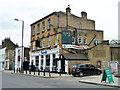
Formerly the Kings Head, Norwood High Street
Now Scandals, a bar and nightclub.
Image: © Robin Webster
Taken: 23 Jul 2011
0.08 miles
10
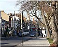
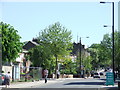
View down Elder Road
With a line of fine old gnarled trees growing in a variety of directions.
After the traffic lights the road becomes Norwood High Street.
In the distance are the towers of St Luke's church and the former fire station.
Image: © Stephen Richards
Taken: 30 Jan 2010
0.08 miles