IMAGES TAKEN NEAR TO
Chestnut Road, LONDON, SE27 9LD
Introduction
This page details the photographs taken nearby to Chestnut Road, SE27 9LD by members of the Geograph project.
The Geograph project started in 2005 with the aim of publishing, organising and preserving representative images for every square kilometre of Great Britain, Ireland and the Isle of Man.

There are currently over 7.5m images from over14,400 individuals and you can help contribute to the project by visiting https://www.geograph.org.uk
Image Map
Images are licensed for reuse under creativecommons.org/licenses/by-sa/2.0
Notes
- Clicking on the map will re-center to the selected point.
- The higher the marker number, the further away the image location is from the centre of the postcode.
Image Listing (188 Images Found)
Images are licensed for reuse under creativecommons.org/licenses/by-sa/2.0
Image
Details
Distance
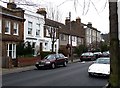
1
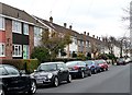
Houses, Chancellor Grove (1)
A group of houses, uncommonly for this area dating probably from the 1960s or 1970s.
Image: © Stephen Richards
Taken: Unknown
0.04 miles
2
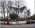
Gothic Lodge, Idmiston Road
Built, according to the listed building description, in the late-C19th. Grade II listed.
A bit of a novelty among the more standard suburban fare in this area. The fretted bargeboards can just be made out in the gables and the porch. Was it ever a lodge to a big house or another building?
Image: © Stephen Richards
Taken: Unknown
0.05 miles
3
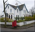
Gothic Lodge, West Norwood
This house on the corner of Idmiston Road and Barston Road looks suitably Gothic, and the name on the gatepost out of sight to the left says 'Gothic Lodge' - see http://www.geograph.org.uk/photo/4281708
Image: © Marathon
Taken: 17 Dec 2014
0.05 miles
4
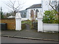
Gothic-style entrance to Gothic Lodge
This is the entrance in Idmiston Road to the house seen in http://www.geograph.org.uk/photo/4281706
Image: © Marathon
Taken: 17 Dec 2014
0.05 miles
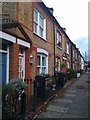
5
Houses, Chancellor Grove (2)
A group of houses of varying vintages and in a variety of styles. The group of three C20th houses still have their original metal Crittall windows.
Image: © Stephen Richards
Taken: Unknown
0.07 miles
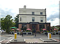
7

The Rosendale, Rosendale Road
At the corner of Park Hall Road. A mid-C19th pub, tarted up in recent years like so many others and now I suppose counts as a gastro-pub. Grade II listed.
Image: © Stephen Richards
Taken: 23 Dec 2012
0.10 miles
8
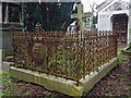
N.A. Mavrogodato monument, Greek Orthodox Cemetery, West Norwood Cemetery
A cross surrounded by a very elaborate cast and wrought iron screen. Nicolas Ambrosios Mavrogodato (d.1890) was, like several of those buried in the Greek Cemetery, one of the diaspora who fled from Ottoman persecution after a rebellion on the island of Chios in 1822. Grade II listed.
West Norwood Cemetery is one of the “Magnificent Seven” cemeteries founded in the early C19th to deal with the expanding population of London. It was laid out by Sir William Tite and opened in 1837. It has 65 Grade II and Grade II* listed monuments.
Image: © Stephen Richards
Taken: 11 Jan 2017
0.10 miles
9
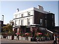
The Rosendale, Public House, West Dulwich
On the junction of Rosendale Road (in front) and Robson Road (on the left, behind the pub).
Image: © David Anstiss
Taken: 2 Oct 2011
0.10 miles
10
Dulwich: The 'Rosendale'
At the crossroads of Rosendale Road and Park Hall Road
Image: © Dr Neil Clifton
Taken: 21 Jul 2012
0.10 miles