IMAGES TAKEN NEAR TO
Chatsworth Way, LONDON, SE27 9HP
Introduction
This page details the photographs taken nearby to Chatsworth Way, SE27 9HP by members of the Geograph project.
The Geograph project started in 2005 with the aim of publishing, organising and preserving representative images for every square kilometre of Great Britain, Ireland and the Isle of Man.

There are currently over 7.5m images from over14,400 individuals and you can help contribute to the project by visiting https://www.geograph.org.uk
Image Map
Images are licensed for reuse under creativecommons.org/licenses/by-sa/2.0
Notes
- Clicking on the map will re-center to the selected point.
- The higher the marker number, the further away the image location is from the centre of the postcode.
Image Listing (154 Images Found)
Images are licensed for reuse under creativecommons.org/licenses/by-sa/2.0
Image
Details
Distance
1
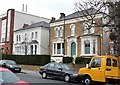
3 and 5 Chestnut Road
A pair of attractive mid-C19th villas. There are several in the road within the West Norwood Conservation Area.
The development of West Norwood began with the breaking up of Lord Thurlow's estate after his death in 1806. Much of this initial phase has since been swept away by subsequent development which accelerated over the second half of the C19th and during the C20th, but there are pockets of houses surviving from the early days, mostly around Knight’s Hill, Norwood High Street/Elder Road and the area between them.
Image: © Stephen Richards
Taken: Unknown
0.04 miles
2
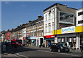
Norwood Road (1)
The east side of Norwood Road in West Norwood is substantially comprised of two distinct terraces, with a bit of modern infill. This terrace, which dates from the second half of the C19th (and is probably earlier than the other one), runs between Robson Road (just out of picture on the right) to Chatsworth Way (just past the reddish building on the far left). See here for the section to the north: Image
The development of West Norwood began with the breaking up of Lord Thurlow's estate after his death in 1806. Much of this initial phase has since been swept away by subsequent development which accelerated over the second half of the C19th and during the C20th, but there are pockets of houses surviving from the early days, mostly around Knight’s Hill, Norwood High Street/Elder Road and the area between them.
Image: © Stephen Richards
Taken: Unknown
0.04 miles
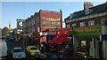
3
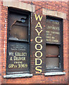
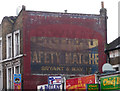
Ghost sign, Chatsworth Way
The sign in the left-hand window reads, "The best equipped workshop in south London / We collect and deliver / Phone GIPSY 3969".
Then "WAY GOODS".
On the right, "Full range of components / Mains transformers / Output / Chokes. Htr / Valves. Chassis etc".
Needless to say, these claims no longer stand up.
Image: © Stephen Richards
Taken: 14 Aug 2019
0.04 miles
4
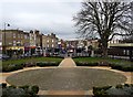
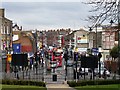
View down Norwood Road (1)
Taken from the portico of St Luke's church.
The area in front of the church has recently been renovated and landscaped.
The library is on the far right. The big tree is a horse chestnut.
Image: © Stephen Richards
Taken: 9 Feb 2010
0.05 miles
5
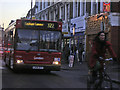
View down Norwood Road (2)
Taken from the green in front of St Luke's church.
A fairly typical volume of traffic - Norwood Road never seems to be without two solid lines of vehicles.
The brown railings, and exotic tree, on the far right mark the entrance to West Norwood cemetery.
Image: © Stephen Richards
Taken: 9 Feb 2010
0.05 miles
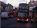
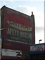
8
Ghost sign, Norwood Road
It took only eight years of living in the area for me to notice this huge example, and then only from the top deck of a bus.
Image: © Stephen Richards
Taken: 14 Mar 2012
0.07 miles
9
Ghost-sign, Norwood Road SE27, West Norwood
Taken from the top deck of a bus. For a closer view, see Image
Image: © Christopher Hilton
Taken: 9 Jul 2015
0.07 miles
10
Ghost-sign, Norwood Road SE27, West Norwood
For the sign in context, see Image
Image: © Christopher Hilton
Taken: 8 Jul 2015
0.07 miles