IMAGES TAKEN NEAR TO
Norwood Road, LONDON, SE27 9AJ
Introduction
This page details the photographs taken nearby to Norwood Road, SE27 9AJ by members of the Geograph project.
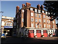
The Geograph project started in 2005 with the aim of publishing, organising and preserving representative images for every square kilometre of Great Britain, Ireland and the Isle of Man.

There are currently over 7.5m images from over14,400 individuals and you can help contribute to the project by visiting https://www.geograph.org.uk
Image Map
Images are licensed for reuse under creativecommons.org/licenses/by-sa/2.0
Notes
- Clicking on the map will re-center to the selected point.
- The higher the marker number, the further away the image location is from the centre of the postcode.
Image Listing (122 Images Found)
Images are licensed for reuse under creativecommons.org/licenses/by-sa/2.0
Image
Details
Distance
1
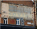
Ghost sign, Ullswater Road
It reads: "...DREYS / LUNCHEONS TEAS / WITH / HOVIS / Golden Brown(?)".
Image: © Stephen Richards
Taken: 9 Nov 2018
0.01 miles
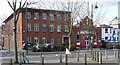
2
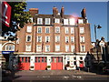
West Norwood Fire Station
Grade II listed fire station with flats above, on Norwood Road.
See http://www.britishlistedbuildings.co.uk/en-492934-west-norwood-fire-station-445-streatham for more details about the building.
Image: © David Anstiss
Taken: 2 Oct 2011
0.03 miles
3
West Norwood Fire Station (2)
Grade II listed fire station with flats above, on Norwood Road.
On the side is the single storey red-brick former wash house. Part of the listing.
See http://www.britishlistedbuildings.co.uk/en-492934-west-norwood-fire-station-445-streatham for more details about the building.
Image: © David Anstiss
Taken: 2 Oct 2011
0.03 miles
4
Former fire station, Norwood Road
A decent London County Council job dating from 1914-15. Grade II listed.
It replaced the original fire station (Image]) and has itself been superseded by Image
Now occupied by the Monkey Puzzle Day Nursery, and Access Self-Storage behind.
Image: © Stephen Richards
Taken: 9 Nov 2018
0.03 miles
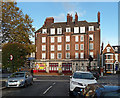
5
242-248 Norwood Road
Brick offices on the left, rather in the style of early-C20th telephone exchanges, and to its right the Salvation Army.
On the far right is No. 242, an early-C19th stuccoed house currently occupied by a company offering lifting platforms for hire, hence the interesting machinery outside. Grade II listed.
Image: © Stephen Richards
Taken: 9 Mar 2011
0.06 miles
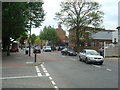
7
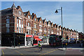
Norwood Road (2)
The east side of Norwood Road in West Norwood is substantially comprised of two distinct terraces, with a bit of modern infill. This terrace, which dates from the second half of the C19th (and is probably later than the other one), runs between Chatsworth Way (just visible on the far right) and Lancaster Avenue (the road to the left). See here for the section to the south: Image
The development of West Norwood began with the breaking up of Lord Thurlow's estate after his death in 1806. Much of this initial phase has since been swept away by subsequent development which accelerated over the second half of the C19th and during the C20th, but there are pockets of houses surviving from the early days, mostly around Knight’s Hill, Norwood High Street/Elder Road and the area between them.
Image: © Stephen Richards
Taken: Unknown
0.08 miles
8

All Nations Christian Centre, west Norwood
This unassuming building on York Hill (road) is a modern church.
Image: © David Anstiss
Taken: 2 Oct 2011
0.09 miles