IMAGES TAKEN NEAR TO
Chapel Road, LONDON, SE27 0UR
Introduction
This page details the photographs taken nearby to Chapel Road, SE27 0UR by members of the Geograph project.
The Geograph project started in 2005 with the aim of publishing, organising and preserving representative images for every square kilometre of Great Britain, Ireland and the Isle of Man.

There are currently over 7.5m images from over14,400 individuals and you can help contribute to the project by visiting https://www.geograph.org.uk
Image Map
Images are licensed for reuse under creativecommons.org/licenses/by-sa/2.0
Notes
- Clicking on the map will re-center to the selected point.
- The higher the marker number, the further away the image location is from the centre of the postcode.
Image Listing (80 Images Found)
Images are licensed for reuse under creativecommons.org/licenses/by-sa/2.0
Image
Details
Distance
1
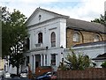
Former Congregational Chapel, Chapel Road
This handsome mid-19th century building has a stucco front with a pediment containing an oculus, a porch of paired Ionic columns in antis, and lower wings. Grade II listed.
It is now used as a children's nursery.
Image: © Stephen Richards
Taken: 23 Jul 2009
0.01 miles
2
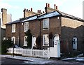
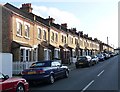
50, 52 and 54 Chapel Road
A group of three charming little brick cottages which probably date from the first half of the C19th.
The development of West Norwood began with the breaking up of Lord Thurlow's estate after his death in 1806. Much of this initial phase has since been swept away by subsequent development which accelerated over the second half of the C19th and during the C20th, but there are pockets of houses surviving from the early days, mostly around Knight’s Hill, Norwood High Street/Elder Road and the area between them.
A light dusting of overnight snow can still be seen.
Image: © Stephen Richards
Taken: 30 Jan 2010
0.03 miles
3
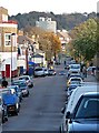
View down Chapel Road
Looking east along Chapel Road and its continuation beyond the traffic lights, Gipsy Road, from near the junction with Knight's Hill.
Image: © Stephen Richards
Taken: Unknown
0.03 miles
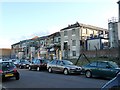
4
Winn and Coales factory, Chapel Road
Although primarily a residential area with a main shopping street, West Norwood also has an industrial area. Well, two streets to be precise. Winn and Coales manufacture "corrosion and chemical resistant coatings and linings for the long term protection of steel and concrete."
Image: © Stephen Richards
Taken: Unknown
0.04 miles
5
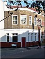
Former Bricklayers' Arms, Chapel Road
Another pub which has gone for a burton (or in this case a Charrington). Happily, the pub sign has survived even though it is in need of some TLC. The pub appears to have been converted to residential use.
Image: © Stephen Richards
Taken: Unknown
0.06 miles
6
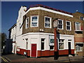
Carpenter's Arms, Public House, West Norwood
Closed pub on the junction of Weaver Walk (on the left) and Chapel Road (in front).
Image: © David Anstiss
Taken: 2 Oct 2011
0.06 miles
7
Winn and Coales factory, Rothschild Street
Although primarily a residential area with a main shopping street, West Norwood also has an industrial area. Well, two streets to be precise. Winn and Coales manufacture "corrosion and chemical resistant coatings and linings for the long term protection of steel and concrete."
Rothschild Street was laid out c1900 on the site of some Huguenot almshouses.
Image: © Stephen Richards
Taken: Unknown
0.07 miles
8
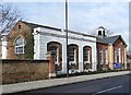
St Luke's Primary School, Elder Road
The left-hand section with channelled rustication dates from around 1850, while the right-hand section, with a charming little belltower, dates from 1908. Grade II listed. The building is within the Elderwood Road Conservation Area.
Image: © Stephen Richards
Taken: Unknown
0.08 miles
9
Ladas Road
The long terraces of pleasing but modest, plain brick houses are not typical of West Norwood, being more redolent of workers' housing in industrial areas.
The development of West Norwood began with the breaking up of Lord Thurlow's estate after his death in 1806, but it accelerated greatly with the arrival of the Crystal Palace railway in 1856; between 1851 and 1901 the population of the district of St. Luke's, Norwood increased from around 4,000 to around 36,000.
Image: © Stephen Richards
Taken: Unknown
0.08 miles
10
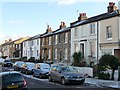
Houses, Chapel Road (2)
These pleasant brick houses probably date from the first half of the C19th.
The development of West Norwood began with the breaking up of Lord Thurlow's estate after his death in 1806. Much of this initial phase has since been swept away by subsequent development which accelerated over the second half of the C19th and during the C20th, but there are pockets of houses surviving from the early days, mostly around Knight’s Hill, Norwood High Street/Elder Road and the area between them.
A light dusting of overnight snow can still be seen.
Image: © Stephen Richards
Taken: 30 Jan 2010
0.09 miles