IMAGES TAKEN NEAR TO
Knights Hill, LONDON, SE27 0SP
Introduction
This page details the photographs taken nearby to Knights Hill, SE27 0SP by members of the Geograph project.
The Geograph project started in 2005 with the aim of publishing, organising and preserving representative images for every square kilometre of Great Britain, Ireland and the Isle of Man.

There are currently over 7.5m images from over14,400 individuals and you can help contribute to the project by visiting https://www.geograph.org.uk
Image Map
Images are licensed for reuse under creativecommons.org/licenses/by-sa/2.0
Notes
- Clicking on the map will re-center to the selected point.
- The higher the marker number, the further away the image location is from the centre of the postcode.
Image Listing (64 Images Found)
Images are licensed for reuse under creativecommons.org/licenses/by-sa/2.0
Image
Details
Distance
1
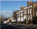
Houses, Knight's Hill
A row of what look like mid-C19th houses on the east side of Knight's Hill.
The development of West Norwood began with the breaking up of Lord Thurlow's estate after his death in 1806, but it accelerated greatly with the arrival of the Crystal Palace railway in 1856; between 1851 and 1901 the population of the district of St. Luke's, Norwood increased from around 4,000 to around 36,000.
Image: © Stephen Richards
Taken: Unknown
0.02 miles
2
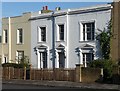
123 Knight's Hill
A house dating probably from the early C19th.
The development of West Norwood began with the breaking up of Lord Thurlow's estate after his death in 1806. Much of this initial phase has since been swept away by subsequent development which accelerated over the second half of the C19th and during the C20th, but there are pockets of houses surviving from the early days, mostly around Knight’s Hill, Norwood High Street/Elder Road and the area between them.
Image: © Stephen Richards
Taken: Unknown
0.03 miles
3
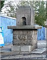
Cattle trough, Chapel Road
On the corner of Chapel Road and Knight's Hill, next to some unsightly recycling bins.
The inscription reads:
"1861
PRESENTED BY
E.H. MOSCROP AND A.W. JAFFRAY
ERECTED BY THE METROPOLITAN
DRINKING FOUNTAIN & CATTLE TROUGH ASSOCIATION"
Image: © Stephen Richards
Taken: Unknown
0.06 miles
4
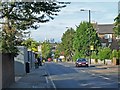
Knights Hill, West Norwood
This is the A215 looking north towards central London.
Image: © Robin Drayton
Taken: 16 Sep 2012
0.07 miles
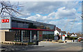
5
Moving Inn Offices, West Norwood
Estate agents office's on the junction of Chapel Road (on the left) and Weaver Walk (on the right).
Image: © David Anstiss
Taken: 2 Oct 2011
0.08 miles
6
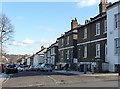
Houses, Chapel Road (1)
These pleasant brick houses probably date from the first half of the C19th.
The development of West Norwood began with the breaking up of Lord Thurlow's estate after his death in 1806. Much of this initial phase has since been swept away by subsequent development which accelerated over the second half of the C19th and during the C20th, but there are pockets of houses surviving from the early days, mostly around Knight’s Hill, Norwood High Street/Elder Road and the area between them.
A light dusting of overnight snow can still be seen.
Image: © Stephen Richards
Taken: 30 Jan 2010
0.08 miles
7
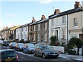
Houses, Chapel Road (2)
These pleasant brick houses probably date from the first half of the C19th.
The development of West Norwood began with the breaking up of Lord Thurlow's estate after his death in 1806. Much of this initial phase has since been swept away by subsequent development which accelerated over the second half of the C19th and during the C20th, but there are pockets of houses surviving from the early days, mostly around Knight’s Hill, Norwood High Street/Elder Road and the area between them.
A light dusting of overnight snow can still be seen.
Image: © Stephen Richards
Taken: 30 Jan 2010
0.08 miles
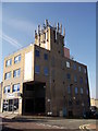
8
Fire station, Knight's Hill
West Norwood's new fire station opened in November 2014, replacing the previous one on Norwood Road. It cost £5 million and was built on the site of a residential facility owned by a local NHS trust.
The far cranes belong to this: Image
Image: © Stephen Richards
Taken: 31 Mar 2015
0.09 miles
9
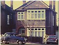
1966 Roxburgh Road West Norwood London SE27
The home of James and Dorothy Greenfield from 1961 to 1988. James worked as a Privy Purse Messenger for the Royal Household at Buckingham Palace, after his retirement from the Metropolitan Police force in 1970.
The car to front of the house was an A35 Austin which was driven to South West France in 1959. Alongside the house is an Austin 1100 which the family took to Southern Austria in the 1960's. Dorothy's mother & sister Edith Emily Thomas nee Baker, & Julie Thomas, lived in the road opposite this house at 17 Bewleys Road from 1959 to 1969.
Image: © Hazel Greenfield
Taken: Unknown
0.10 miles
10
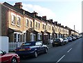
Ladas Road
The long terraces of pleasing but modest, plain brick houses are not typical of West Norwood, being more redolent of workers' housing in industrial areas.
The development of West Norwood began with the breaking up of Lord Thurlow's estate after his death in 1806, but it accelerated greatly with the arrival of the Crystal Palace railway in 1856; between 1851 and 1901 the population of the district of St. Luke's, Norwood increased from around 4,000 to around 36,000.
Image: © Stephen Richards
Taken: Unknown
0.10 miles