IMAGES TAKEN NEAR TO
Wolfington Road, LONDON, SE27 0RH
Introduction
This page details the photographs taken nearby to Wolfington Road, SE27 0RH by members of the Geograph project.
The Geograph project started in 2005 with the aim of publishing, organising and preserving representative images for every square kilometre of Great Britain, Ireland and the Isle of Man.

There are currently over 7.5m images from over14,400 individuals and you can help contribute to the project by visiting https://www.geograph.org.uk
Image Map
Images are licensed for reuse under creativecommons.org/licenses/by-sa/2.0
Notes
- Clicking on the map will re-center to the selected point.
- The higher the marker number, the further away the image location is from the centre of the postcode.
Image Listing (114 Images Found)
Images are licensed for reuse under creativecommons.org/licenses/by-sa/2.0
Image
Details
Distance
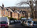
1
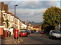
St Julian's Farm Road (6)
Looking east down St Julian's Farm Road from near the junction with Thurlestone Road.
St Julian's Farm Road has several distinct stylistic groups of houses, all probably dating from the second half of the C19th (except for a few at the top end built in the 1920s/1930s).
The development of West Norwood began with the breaking up of Lord Thurlow's estate after his death in 1806, but it accelerated greatly with the arrival of the Crystal Palace railway in 1856; between 1851 and 1901 the population of the district of St. Luke's, Norwood increased from around 4,000 to around 36,000.
Image: © Stephen Richards
Taken: Unknown
0.03 miles
2
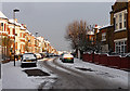
Snow in Thurlestone Road
Seen after a most unusual second December snowfall. These houses probably date from the second half of the C19th.
The development of West Norwood began with the breaking up of Lord Thurlow's estate after his death in 1806. Much of this initial phase has since been swept away by subsequent development which accelerated over the second half of the C19th and during the C20th, but there are pockets of houses surviving from the early days, mostly around Knight’s Hill, Norwood High Street/Elder Road and the area between them.
Image: © Stephen Richards
Taken: 20 Dec 2010
0.06 miles
3
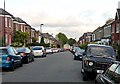
Thornlaw Road (3)
Looking east down Thornlaw Road from near the junction with Thurlby Road.
These houses were probably built in the second half of the C19th.
The development of West Norwood began with the breaking up of Lord Thurlow's estate after his death in 1806, but it accelerated greatly with the arrival of the Crystal Palace railway in 1856; between 1851 and 1901 the population of the district of St. Luke's, Norwood increased from around 4,000 to around 36,000.
Image: © Stephen Richards
Taken: Unknown
0.08 miles
4
4 and 6 Streatham, West Norwood
2 Grade II listed houses on Thornlaw Road.
See http://www.britishlistedbuildings.co.uk/en-204707-4-and-6-streatham for more details.
Image: © David Anstiss
Taken: 2 Oct 2011
0.10 miles
5
Former Arnold & Jane Gabriel Home
This former Jewish orphanage was built in 1910 according to the inscription. When photographed, it recently had been offices of a housing trust, but the remaining grounds looked rather unkempt and their signs had been taken down, so they may have moved out.
Image: © Robin Webster
Taken: 23 Jul 2011
0.11 miles
6
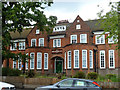
Former Arnold & Jane Gabriel Home
This former Jewish orphanage was built in 1910 according to the inscription. When photographed, it recently had been offices of a housing trust, but the remaining grounds looked rather unkempt and their signs had been taken down, so they may have moved out.
Image: © Robin Webster
Taken: 23 Jul 2011
0.11 miles
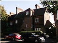
7
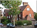
4 and 6 Thornlaw Road
Amid the mostly Victorian and Edwardian streets of West Norwood, these two houses stand out somewhat. They were designed by Ernest George and Harold Peto in 1882-83. The tile-hung upper storey, prominent chimneys and white-painted sash windows are common motifs of Arts and Crafts architecture. Grade II listed.
George lived in Streatham for some years and designed several buildings in the area.
Image: © Stephen Richards
Taken: Unknown
0.11 miles
8
Former Arnold & Jane Gabriel Home
A rear view of this former Jewish orphanage, built in 1910 according to the inscription on the front. It was recently offices of a housing trust, but the remaining grounds look rather unkempt and their signs have been taken down, so they may have moved out.
Image: © Robin Webster
Taken: 23 Jul 2011
0.11 miles
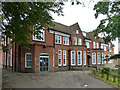
9
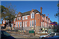
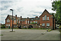
Julian's School, Wolfington Road
Educational planners around the country have been caught on the hop by an unexpected increase in the birth rate leading to a lack of school places. West Norwood has been one such affected area, something which Lambeth Council is now attempting to address. The primary school had just opened a week or two before, even though the rear is still a building site and at the front workmen can be seen finishing off the landscaping. The outdoor space - on the right - is rather cramped.
This pleasant Arts and Crafts style building began life as a Jewish orphanage - a panel above the entrance bears the inscription, "Arnold and Jane Gabriel Home 1910". Prior to the school, it was used as offices by a local housing association.
Image: © Stephen Richards
Taken: 6 Oct 2012
0.12 miles
10
St Julian's Farm Road (7)
Looking east down St Julian's Farm Road from near the junction with Casewick Road. Just out of shot round the corner it meets Knight's Hill. The trees of West Norwood Cemetery are visible in the background
St Julian's Farm Road has several distinct stylistic groups of houses, all probably dating from the second half of the C19th (except for a few at the top end built in the 1920s/1930s).
The development of West Norwood began with the breaking up of Lord Thurlow's estate after his death in 1806, but it accelerated greatly with the arrival of the Crystal Palace railway in 1856; between 1851 and 1901 the population of the district of St. Luke's, Norwood increased from around 4,000 to around 36,000.
Image: © Stephen Richards
Taken: 25 Nov 2009
0.12 miles