Julian's School, Wolfington Road
Introduction
The photograph on this page of Julian's School, Wolfington Road by Stephen Richards as part of the Geograph project.
The Geograph project started in 2005 with the aim of publishing, organising and preserving representative images for every square kilometre of Great Britain, Ireland and the Isle of Man.

There are currently over 7.5m images from over 14,400 individuals and you can help contribute to the project by visiting https://www.geograph.org.uk
Julian's School, Wolfington Road
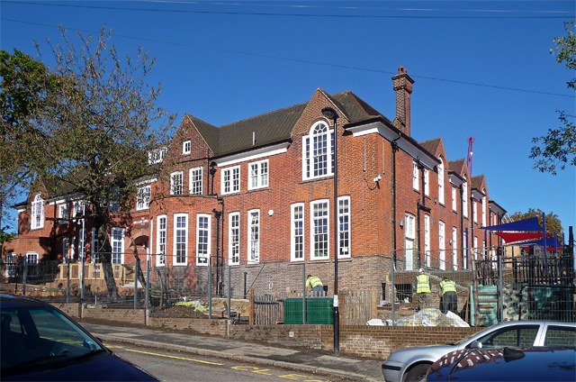
Image: © Stephen Richards Taken: 6 Oct 2012
Educational planners around the country have been caught on the hop by an unexpected increase in the birth rate leading to a lack of school places. West Norwood has been one such affected area, something which Lambeth Council is now attempting to address. The primary school had just opened a week or two before, even though the rear is still a building site and at the front workmen can be seen finishing off the landscaping. The outdoor space - on the right - is rather cramped. This pleasant Arts and Crafts style building began life as a Jewish orphanage - a panel above the entrance bears the inscription, "Arnold and Jane Gabriel Home 1910". Prior to the school, it was used as offices by a local housing association.
Images are licensed for reuse under creativecommons.org/licenses/by-sa/2.0
Image Location
Latitude
51.431232
Longitude
-0.105434