IMAGES TAKEN NEAR TO
Lansdowne Hill, LONDON, SE27 0LP
Introduction
This page details the photographs taken nearby to Lansdowne Hill, SE27 0LP by members of the Geograph project.
The Geograph project started in 2005 with the aim of publishing, organising and preserving representative images for every square kilometre of Great Britain, Ireland and the Isle of Man.

There are currently over 7.5m images from over14,400 individuals and you can help contribute to the project by visiting https://www.geograph.org.uk
Image Map
Images are licensed for reuse under creativecommons.org/licenses/by-sa/2.0
Notes
- Clicking on the map will re-center to the selected point.
- The higher the marker number, the further away the image location is from the centre of the postcode.
Image Listing (159 Images Found)
Images are licensed for reuse under creativecommons.org/licenses/by-sa/2.0
Image
Details
Distance
1
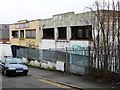
Disused factories, Canterbury Grove
Having walked past these buildings countless times thinking that I should take a photo just in case they are demolished, I finally turned up just as the first steps in that process were being taken. Some of the metal windows had been removed. There are some nice little Art Deco-ish details on these otherwise modest industrial buildings. However, having lain empty for at least 3-4 years, the site is being cleared for a mixed residential-commercial development, and soon these buildings will be history.
Image: © Stephen Richards
Taken: Unknown
0.03 miles
2
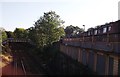
Railway Line to West Norwood
As seen from Image
This line leads from Tulse Hill towards West Norwood and onwards to Crystal Palace. On the right is Mount Villas (road) partially over the line.
In the background is a footbridge between two sections of Canterbury Grove.
Image: © David Anstiss
Taken: 2 Oct 2011
0.03 miles
3
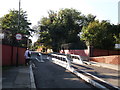
Lansdowne Hill road bridge
This road leads from Norwood Road towards Royal Circus.
It passes over the railway between West Norwood and Tulse Hill.
Image: © David Anstiss
Taken: 2 Oct 2011
0.04 miles
4
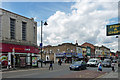
Norwood Road (3)
The west side of the street is much less coherent than the east side (Image] and Image]). The tiled front of Sainsbury's, on the corner of Lansdowne Hill, looks inter-war, the remainder mostly Victorian.
The chippie on the right is not as parsimonious as the photo suggests.
Image: © Stephen Richards
Taken: 30 Jul 2012
0.07 miles
5
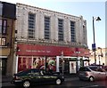
Sainsbury's Local, West Norwood
Mini supermarket on the junction of Knight's Hill (in front) and Lansdowne Hill (on the right).
Opposite - Image
Image: © David Anstiss
Taken: 2 Oct 2011
0.07 miles
6
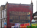
Ghost sign, Norwood Road
It took only eight years of living in the area for me to notice this huge example, and then only from the top deck of a bus.
Image: © Stephen Richards
Taken: 14 Mar 2012
0.08 miles
7
Ghost-sign, Norwood Road SE27, West Norwood
Taken from the top deck of a bus. For a closer view, see Image
Image: © Christopher Hilton
Taken: 9 Jul 2015
0.08 miles
8
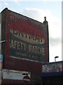
Ghost-sign, Norwood Road SE27, West Norwood
For the sign in context, see Image
Image: © Christopher Hilton
Taken: 8 Jul 2015
0.08 miles
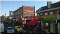
9
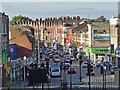
Norwood Road, West Norwood
Viewed from the steps of St Luke's Church http://www.geograph.org.uk/photo/3137929 .
Image: © Robin Drayton
Taken: 16 Sep 2012
0.09 miles
10
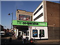
The Co-operative Supermarket, West Norwood
Mini supermarket on the junction of Norwood Road (on the left) and Chestnut Road (in front). Was a former Somerfield Store.
Image: © David Anstiss
Taken: 2 Oct 2011
0.09 miles