IMAGES TAKEN NEAR TO
Cheviot Road, LONDON, SE27 0LG
Introduction
This page details the photographs taken nearby to Cheviot Road, SE27 0LG by members of the Geograph project.
The Geograph project started in 2005 with the aim of publishing, organising and preserving representative images for every square kilometre of Great Britain, Ireland and the Isle of Man.

There are currently over 7.5m images from over14,400 individuals and you can help contribute to the project by visiting https://www.geograph.org.uk
Image Map
Images are licensed for reuse under creativecommons.org/licenses/by-sa/2.0
Notes
- Clicking on the map will re-center to the selected point.
- The higher the marker number, the further away the image location is from the centre of the postcode.
Image Listing (66 Images Found)
Images are licensed for reuse under creativecommons.org/licenses/by-sa/2.0
Image
Details
Distance
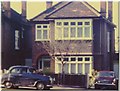
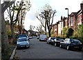
1
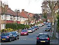
Cheviot Road
Looking north-east towards Knight's Hill. Most of West Norwood was developed in Victorian and Edwardian times but there is also a fair amount of housing from between the wars.
Image: © Stephen Richards
Taken: Unknown
0.05 miles
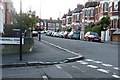
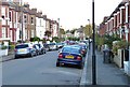
2
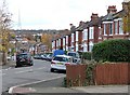
Casewick Road (1)
Looking east from Lamberhurst Road.
These houses were probably built in the second half of the C19th. The development of West Norwood began with the breaking up of Lord Thurlow's estate after his death in 1806, but it accelerated greatly with the arrival of the Crystal Palace railway in 1856; between 1851 and 1901 the population of the district of St. Luke's, Norwood increased from around 4,000 to around 36,000.
In the distance is the Crystal Palace television mast.
Image: © Stephen Richards
Taken: Unknown
0.05 miles
3
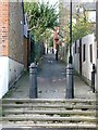
Hale Path
A short alley which runs between Thornlaw Road and Casewick Road. This shot is taken from the latter.
Image: © Stephen Richards
Taken: Unknown
0.07 miles
4
Zebra Spider, West Norwood
The zebra spider (Salticus scenicus) is common throughout the UK. It is a jumping spider, so it does not build a web, but relies on its four pairs of large eyes to locate prey and its jumping ability to pounce and capture it.
Image: © Stephen Richards
Taken: 23 Jun 2010
0.07 miles
5
1966 Roxburgh Road West Norwood London SE27
The home of James and Dorothy Greenfield from 1961 to 1988. James worked as a Privy Purse Messenger for the Royal Household at Buckingham Palace, after his retirement from the Metropolitan Police force in 1970.
The car to front of the house was an A35 Austin which was driven to South West France in 1959. Alongside the house is an Austin 1100 which the family took to Southern Austria in the 1960's. Dorothy's mother & sister Edith Emily Thomas nee Baker, & Julie Thomas, lived in the road opposite this house at 17 Bewleys Road from 1959 to 1969.
Image: © Hazel Greenfield
Taken: Unknown
0.07 miles
6
Casewick Road (2)
Looking roughly west from the junction with Tredwell Road.
These houses were probably built in the second half of the C19th. The development of West Norwood began with the breaking up of Lord Thurlow's estate after his death in 1806, but it accelerated greatly with the arrival of the Crystal Palace railway in 1856; between 1851 and 1901 the population of the district of St. Luke's, Norwood increased from around 4,000 to around 36,000.
Image: © Stephen Richards
Taken: Unknown
0.08 miles
7
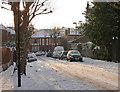
Snow in Thurlby Road (2)
Seen after a most unusual second December snowfall. See here for a similar, snow-less view: Image
Image: © Stephen Richards
Taken: 20 Dec 2010
0.11 miles
8
Thurlby Road (3)
Looking south down the short section of Thurlby Road between St Julian's Farm Road, from where the picture was taken, and Thornlaw Road at the bottom.
No houses face onto this section of Thurlby Road, which just has access to garages and similar.
The development of West Norwood began with the breaking up of Lord Thurlow's estate after his death in 1806, but it accelerated greatly with the arrival of the Crystal Palace railway in 1856; between 1851 and 1901 the population of the district of St. Luke's, Norwood increased from around 4,000 to around 36,000.
Image: © Stephen Richards
Taken: Unknown
0.11 miles
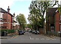
9
Thornlaw Road (2)
Looking west along the top end of Thornlaw Road, where it meets Lamberhurst Road, from near the junction with Thurlby Road.
These houses were probably built in the second half of the C19th.
The development of West Norwood began with the breaking up of Lord Thurlow's estate after his death in 1806, but it accelerated greatly with the arrival of the Crystal Palace railway in 1856; between 1851 and 1901 the population of the district of St. Luke's, Norwood increased from around 4,000 to around 36,000.
Image: © Stephen Richards
Taken: Unknown
0.13 miles
10
Casewick Road (3)
Looking roughly north-east from near the junction with Tredwell Road.
These houses were probably built in the second half of the C19th. The development of West Norwood began with the breaking up of Lord Thurlow's estate after his death in 1806, but it accelerated greatly with the arrival of the Crystal Palace railway in 1856; between 1851 and 1901 the population of the district of St. Luke's, Norwood increased from around 4,000 to around 36,000.
Image: © Stephen Richards
Taken: Unknown
0.14 miles