IMAGES TAKEN NEAR TO
Knights Hill, LONDON, SE27 0JD
Introduction
This page details the photographs taken nearby to Knights Hill, SE27 0JD by members of the Geograph project.
The Geograph project started in 2005 with the aim of publishing, organising and preserving representative images for every square kilometre of Great Britain, Ireland and the Isle of Man.

There are currently over 7.5m images from over14,400 individuals and you can help contribute to the project by visiting https://www.geograph.org.uk
Image Map (Loading...)


Getting Data...Please wait
Leaflet Map data © OpenStreetMap
Images are licensed for reuse under creativecommons.org/licenses/by-sa/2.0
Notes
- Clicking on the map will re-center to the selected point.
- The higher the marker number, the further away the image location is from the centre of the postcode.
Image Listing (211 Images Found)
Images are licensed for reuse under creativecommons.org/licenses/by-sa/2.0
Image
Details
Distance
1
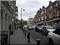
Knight's Hill, West Norwood
Part of the A215, just south of West Norwood station.
Image: © Richard Vince
Taken: 14 May 2016
0.02 miles
2
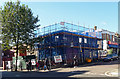
66-70 Knight's Hill
This innocuous two-storey building on the corner of Wolfington Road was being demolished to be replaced by shops and nine flats, developers once again demonstrating their ability to distort the fabric of space.
Previously this had been occupied by a couple of secondhand furniture shops; the newsagent next door (far right) told me that he remembered it being a ladies' hairdresser's and a butcher's. There was no implication of any sort of Sweeney Todd connection.
Partly visible to the left is Rosebery's auction house.
Image: © Stephen Richards
Taken: 6 Oct 2012
0.02 miles
3
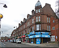
23-45 Knight's Hill
A prosaic Victorian group, although the first building - portentously named Knight's Hall - has an improbable Corinthian portico. The building is dated 1885.
It houses, also improbably, the Portico Gallery, but in common with much of suburbia most of the other buildings are cafes or takeaways. We also have a nail bar (another growth area), a mortgage consultant, cab firm and MENCAP offices at the end.
Image: © Stephen Richards
Taken: 6 Feb 2013
0.02 miles
4
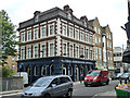
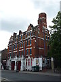
The Norwood Hotel
Later renamed The Great North Wood.
Image: © Robin Webster
Taken: 23 Jul 2011
0.03 miles
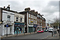
5
44-64 Knight's Hill
A fairly standard late-Victorian/Edwardian parade, running between the railway and Wolfington Road. Compared to even some of those in Streatham (e.g. Image]) it is very unassuming.
In common with much of suburbia most of the shops are cafes/takeaways, convenience stores or newsagents, but at no. 46 we have Centre 70, a Citizens' Advice Bureau, and there is also a nail bar (a growth area) and a carpet shop.
Image: © Stephen Richards
Taken: 6 Feb 2013
0.03 miles
6
Cotswold Street, West Norwood
Between Norwood High Street and Knight's Hill (in the distance), along the south side of West Norwood station.
Image: © Richard Vince
Taken: 14 May 2016
0.04 miles
7
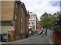
Julian's School, Wolfington Road
Educational planners around the country have been caught on the hop by an unexpected increase in the birth rate leading to a lack of school places. West Norwood has been one such affected area, something which Lambeth Council is now attempting to address. The primary school had just opened a week or two before, even though the rear is still a building site and at the front workmen can be seen finishing off the landscaping. The outdoor space - on the right - is rather cramped.
This pleasant Arts and Crafts style building began life as a Jewish orphanage - a panel above the entrance bears the inscription, "Arnold and Jane Gabriel Home 1910". Prior to the school, it was used as offices by a local housing association.
Image: © Stephen Richards
Taken: 6 Oct 2012
0.04 miles
8
Former Fire Station, Norwood High Street
See Image for description
Image: © Roger W Haworth
Taken: 5 Aug 2011
0.04 miles
9

Former Fire Station, Norwood High Street - doors
See Image for description. These are the doors for the fire engines. There is a date of 1881 and below that the "logo": MBW - Metropolitan Board of Works http://en.wikipedia.org/wiki/Metropolitan_Board_of_Works
Image: © Roger W Haworth
Taken: 5 Aug 2011
0.04 miles
10
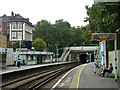
West Norwood station
The building high on the left is a pub called, at the time, the Norwood Hotel.
Image: © Robin Webster
Taken: 23 Jul 2011
0.05 miles